 |
Hillsborough County |
 |
Land Development Code |
 |
Article III. SPECIAL DISTRICTS |
 |
Part 3.02.00. INTERSTATE-75 PLANNED DEVELOPMENT DISTRICTS |
§ 3.02.04. Specific Review Criteria
A.
Locational Criteria
1.
Residential. Residential developments are permitted anywhere in IPD 1, 2 and 3 districts.
2.
Commercial. Commercial development shall meet at least one of the following locational requirements.
a.
Commercial development shall be permitted anywhere in the IPD-3 district.
b.
Commercial development in IPD-1 or IPD-2 districts shall be:
(1)
Approved as part of a mixed use development, or
(2)
Located at arterial and collector road intersections as defined and allowed for in the I-75 Corridor Long Range Transportation Plan, or
(3)
Infill development within existing strip commercial areas.
3.
Office. The intensity, size, scale and height of office development shall reflect the characteristics of the intersection at which it is located. The most intense and tallest office developments would be located at rail transit stations, and the less intense office developments would be located at other intersections shown on the current MPO Long Range Transportation Cost Affordable Plan Map in effect at the time of the application for development approval. In addition, office development shall meet at least one of the following locational requirements.
a.
Office development shall be permitted anywhere in the IPD-3 district.
b.
Office development in the IPD-2 district shall be:
(1)
Approved as part of a mixed use development, or
(2)
Located as defined and allowed for in the I-75 Corridor Plan, or
(3)
Allowed as infill development within areas that are developed with non-residential uses.
c.
Office development in the IPD-1 district shall be:
(1)
Approved as part of a mixed use development, or
(2)
Located at arterial and collector intersections as defined and allowed for in the I-75 Corridor Plan, or
(3)
Allowed as infill development within areas that are developed with non-residential uses.
4.
Industrial. Industrial development shall meet the following locational criteria:
a.
Unless specifically approved by the Board of County Commissioners, development shall not take access through local residential streets.
b.
Development shall be discouraged next to existing residential development except when the industrial use is part of a mixed use development containing residential uses or is part of a mixed use development which provides a transition of uses away from the existing residential development.
5.
Mixed Use Developments. All requirements and criteria found in the single use districts shall apply to mixed use developments.
B.
Open Space: IPD-1 and IPD-2 Districts.
1.
The site shall be landscaped so that 40 percent of the open space will be covered by tree canopy within ten years. The Plant Unit Alternatives found in 3.02.04 K shall be used to determine the area of canopy coverage in all UL districts. The projected ten year area for canopy coverage for each Plant Unit Alternative is listed below:
Alternative No. 1 = 3,000 square feet
Alternative No. 2 = 2,000 square feet
Alternative No. 3 = 2,000 square feet
2.
Section 3.02.04 K highlights examples of plant materials that can be used for the landscaping of open space. An exception to this rule may be cases where native vegetation is to be left undisturbed as part of the open space requirement. In this case, the present vegetation may be credited toward the 40 percent canopy requirement.
C.
Street Furniture: IPD-1 and IPD-2 Districts.
1.
Street furniture shall be provided in all IPD-1 and IPD-2 districts except for residential developments of less than 14 dwelling units per acre. A plan shall be submitted at the time of preliminary plat/site development plan or, construction plan where the preliminary process is waived, review showing the type of street furniture to be provided. Wherever, a theme or similarity in street furniture has been coordinated and established within an area, the adjacent developments are encouraged to expand that same theme, especially along the project's frontage, in order to provide that link of consistency and uniformity needed to create and expand the urban village concept.
2.
In residential developments of 14 dwelling units per acre or more, street furniture plans shall contain, at a minimum, pedestrian walk lighting, waste bins, and seating facilities for every 400 feet of walk. The provision of street furniture is encouraged in residential developments of less than 14 dwelling units per acre. Pedestrian areas shall be lighted within the permitted range of illumination along the pedestrian area as indicated in Section 3.02.04 U. Commercial and office areas shall comply with the Commercial and Office Center design requirements of 3.02.04 J. In office and industrial areas, the street furniture shall create outdoor areas conducive to the enjoyment of employees during lunch or other breaks. Major pedestrian corridors in residential areas which are shown as connecting to other developments on the non-motorizing circulation plan maps, shall be provided with seating areas, lighting and waste bins, at such a spacing or placement as to provide a secure pedestrian environment and places to rest and/or enjoy a view.
D.
Open Space: IPD-3 District.
1.
IPD-3 district developments shall contain a minimum of 20 percent open space. Such open space areas may be 100 percent paved or developments may have a mix of paved and pervious areas. Intensive use of the open areas is permitted to achieve the objective of true urban spaces. These areas may be at normal grade or may be raised or lowered.
2.
In general, retention areas contained with concrete retaining walls do not count as open space. However, when such facilities serve as both a water feature and retention basin, and where decks, walks, plazas, and other pedestrian areas adjoining such water feature-retention facilities are used for retail, restaurants, pedestrian plazas or walks, or other useful outdoor functions, the water feature-retention facility may be counted toward the open space requirement.
3.
The trees planted in pervious areas shall be designed to reach a 60 percent coverage within ten years after installation. In paved areas, planters and trees shall be required, but their placement shall be flexible. The site plan shall be reviewed to determine shading characteristics of the open space and may include in addition to the proposed trees, awnings, canopies, trellises, and buildings to produce outdoor spaces that are comfortable throughout the year.
4.
The design of urban spaces shall create a pedestrian precinct where pedestrians may gain access to the various uses, and where these spaces may be used by customers, employees, and the public for walking between uses and general enjoyment. The size and shape, the direction of movements, and sequence of special experiences in these areas is important to the development of a viable pedestrian precinct.
5.
In evaluating the quality of urban spaces in the IPD-3 districts, the Administrator's staff shall review the D/H (Depth to Height) ratio of the various spaces and the variation in the spaces. Urban spaces should have D/H values between .5 and 5.0. Small D/H values are very enclosing and either should be used as connectors between larger spaces (pedestrian precincts) or be given very careful review as to their ability to function as comfortable pedestrian precincts. Narrow spaces with low D/H ratios and little room for planting may have fewer trees and more decorative plantings; conversely, wider spaces will require plantings to provide adequate shading. In general, the amount of planting is expected to increase with the D/H ratio of the space.
E.
Street Furniture: IPD-3 District
All IPD-3 districts shall have street furniture. The only optional items are water features, fountains, and sculptures. See 3.02.05 on Public Art. Street furniture is required to provide a high quality pedestrian experience in open spaces; it shall be integrated into the architectural and site design of the area, and provide interesting seating areas as well as walking spaces.
F.
Parking Lot Landscaping
The following parking lot landscaped buffer area requirements shall be provided by all developments in the urban level districts. The Landscaping Regulations of this Code shall be followed except:
1.
The buffers along streets for parking shall be eliminated and the following street buffers shall be substituted. The street buffers shall constitute the minimum setback for parking. All dimensions for street setbacks or buffers shall be taken from the closest right-of-way line to the closest exterior wall of the structure nearest the edge of paving.
2.
Figures 3.7 and 3.8 show the legal depictions of setback distances and vertical screening dimensions outlined above. Figures 3.7 and 3.8 also show examples of the acceptable alternatives that may be used in order to meet the vertical screening requirement. A single alternative or a combination of alternatives may be used. Landscaping is required within all buffer areas, however the placement shall be flexible provided that the vertical screening requirement is met. All planted areas within the buffer areas shall be credited toward the canopy coverage requirement indicated in 3.02.04 B.
G.
Setbacks and Designs for Parking Garages
This section shall set forth the setbacks and design for parking garages. Developments approved in the IPD-3 district shall have lesser setbacks than those approved in the IPD-1 and IPD-2 districts.
1.
Where the height of the parking garage exceeds 30 feet in the IPD-1 and IPD-2 districts, and 50 feet in the IPD-3 district, the structures shall be setback an additional foot for every foot in height over 30 and 50 feet respectively.
2.
In an effort to encourage high quality design, a developer may be exempted from the additional 1:1 setback requirement as stated above. An exemption may be granted by demonstrating that the parking garage is designed as an integral component of the overall site, architecturally finished on all sides and reflecting the use of materials displayed by the main structure(s). In addition, the developer must demonstrate, through a drawing, landscape treatment that exceeds the minimum requirements. The Administrator shall review parking garage drawings and make a recommendation on the setback exemption at the time of rezoning.
3.
Figures 3.9 and 3.10 show the legal depictions of the setback distances and vertical screening dimensions as indicated. Figures 3.9 and 3.10 show the acceptable alternatives that may be used in order to meet the vertical screening requirement. A single alternative or a combination of alternatives may be used. Landscaping is required within all buffer areas, however the placement shall be flexible provided that the vertical screening requirement is met. All planted areas within the buffer areas shall be credited toward the canopy coverage requirement indicated in 3.02.04 B.
H.
Street Buffer and Setbacks for Buildings
1.
This section shall set forth the setbacks for buildings as indicated previously for parking lots. Developments approved in the IPD-3 district shall have lesser setbacks than those approved in the IPD-1 and IPD-2 districts. However, where the developer can demonstrate that a proposed project in the IPD-2 district is truly an urban development, the developer may then apply the more urban setbacks of the IPD-3 district to the proposed project. The criteria used in reviewing a true urban development shall be a development containing mixed uses, areas for the gathering of people with attractors, activities, items of visual interest, seating areas and other urban elements such as pedestrian amenities, works of art, and increased landscaping.
2.
The setbacks for buildings in the IPD-3 district shall vary depending on whether the use takes access at grade in front, takes access from an elevated pedestrian walk, or takes access perpendicular to the street or on the opposite side of the building from the street in question.
3.
Figure 3.11 shows setbacks for IPD-1 and IPD-2 districts, and Figures 3.12 and 3.13 are intended to be legal depictions in regard to the setback distances and vertical screening dimensions as indicated. The illustrations show the acceptable alternatives that may be used in order to meet the vertical screening requirement. A single alternative or a combination of alternatives may be used. Landscaping is required within all buffer areas, however the placement shall be flexible provided that the vertical screening requirement is met. All planted areas within the buffer areas shall be credited toward the canopy coverage requirement indicated in 3.02.04 B.
I.
Landscaping of Littoral Zones of Detention Ponds
All IPD districts shall provide landscaping for the littoral zone of stormwater detention ponds. The appropriate plant types for landscaping and side slopes shall be based on guidelines found in the Southwest Florida Water Management District's (SWFWMD) Permit Information Manual. Detention ponds which are used as a water feature, and contain littoral zone landscaping, may be included in open space calculations. The area calculated to be included as open space shall be landward of the design high-water elevation.
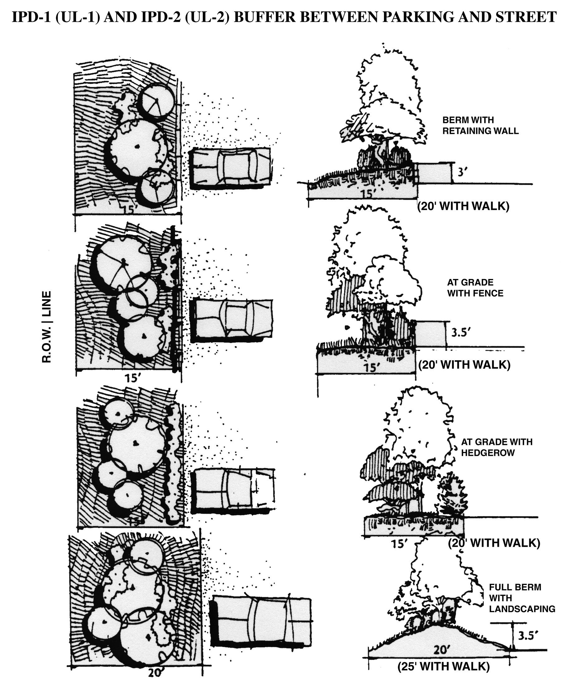
Figure 3.7, IPD-1 (UL-1) and IPD-2 (UL-2) Buffer between Parking and Street
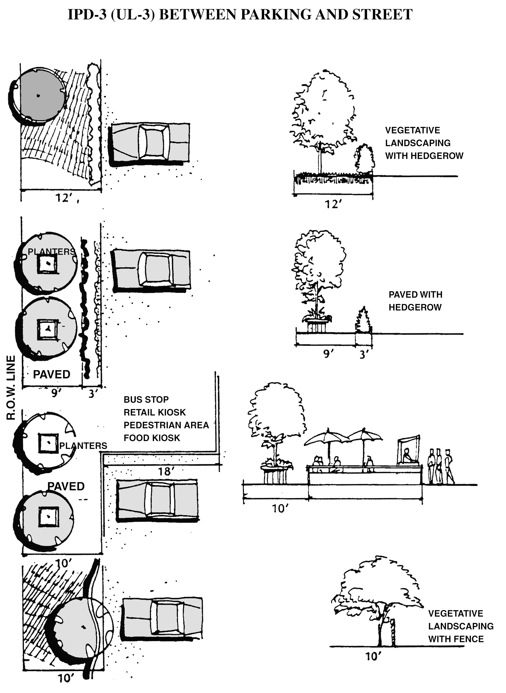
Figure 3.8, IPD-3 (UL-3) Buffer between Parking and Street
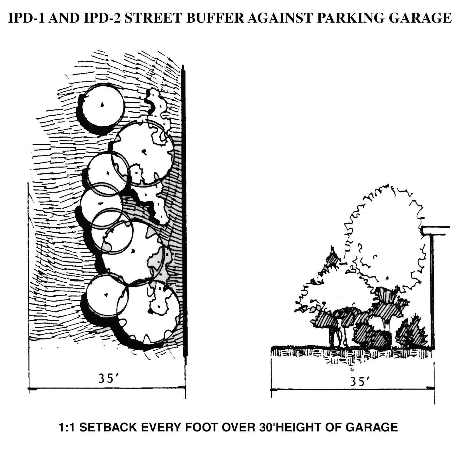
Figure 3.9, IPD-1 (UL-1) and IPD-2 (UL-2) Street Buffer against Parking Garage
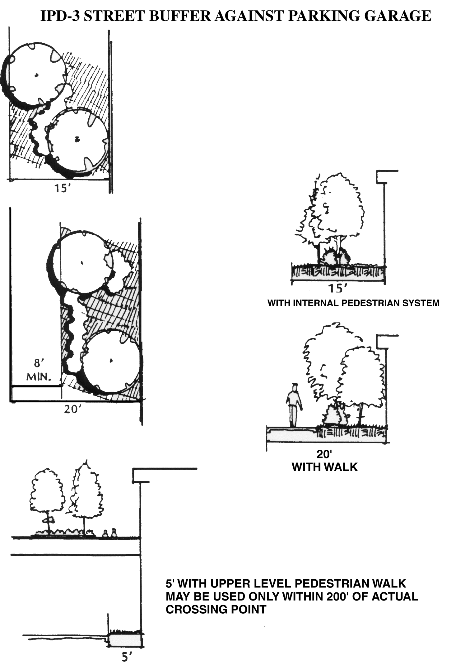
Figure 3.10, IPD-3 (UL-3) Street Buffer against Parking Garage
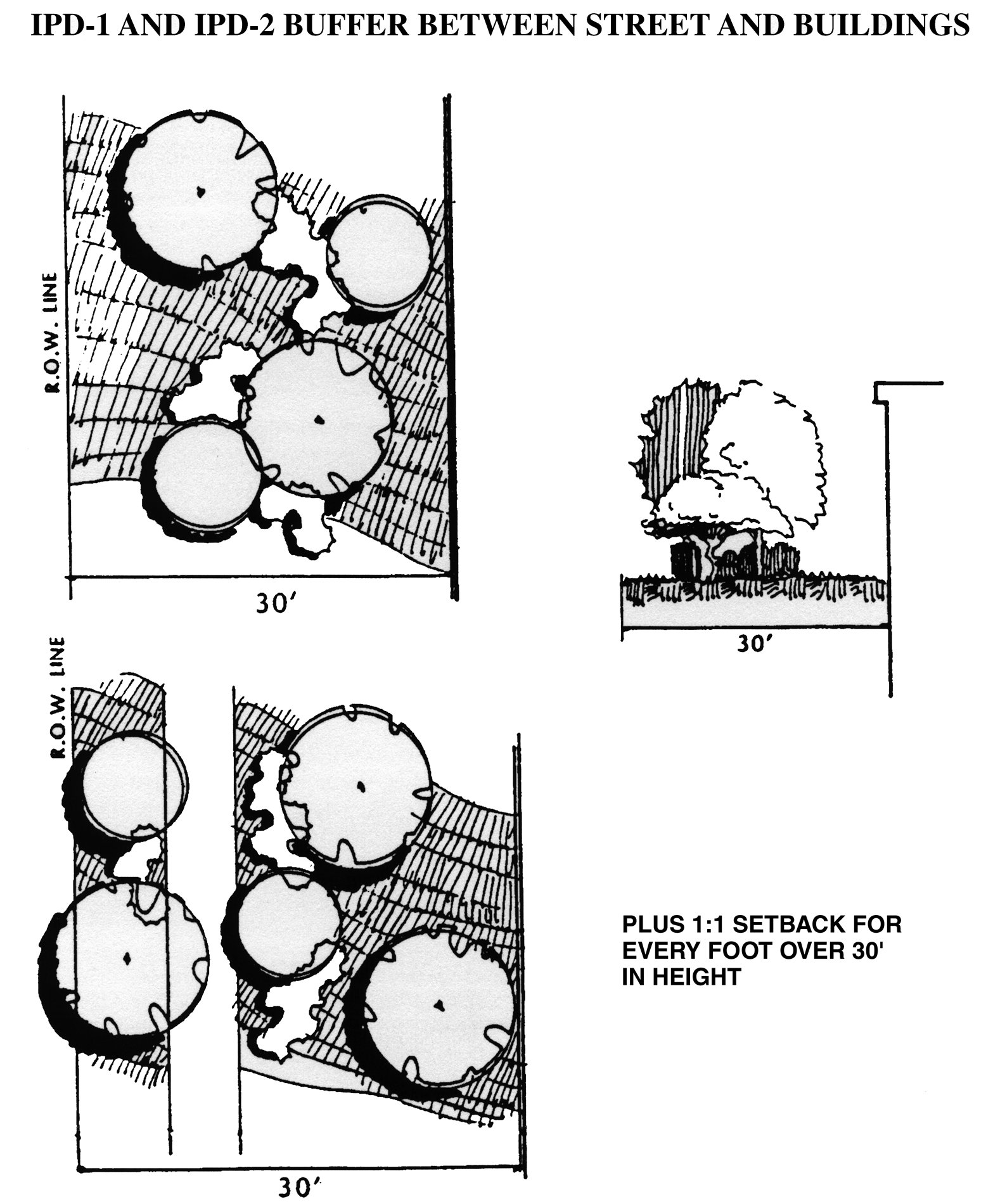
Figure 3.11, IPD-1 (UL-1) and IPD-2 (UL-2) Buffer between Street and Buildings
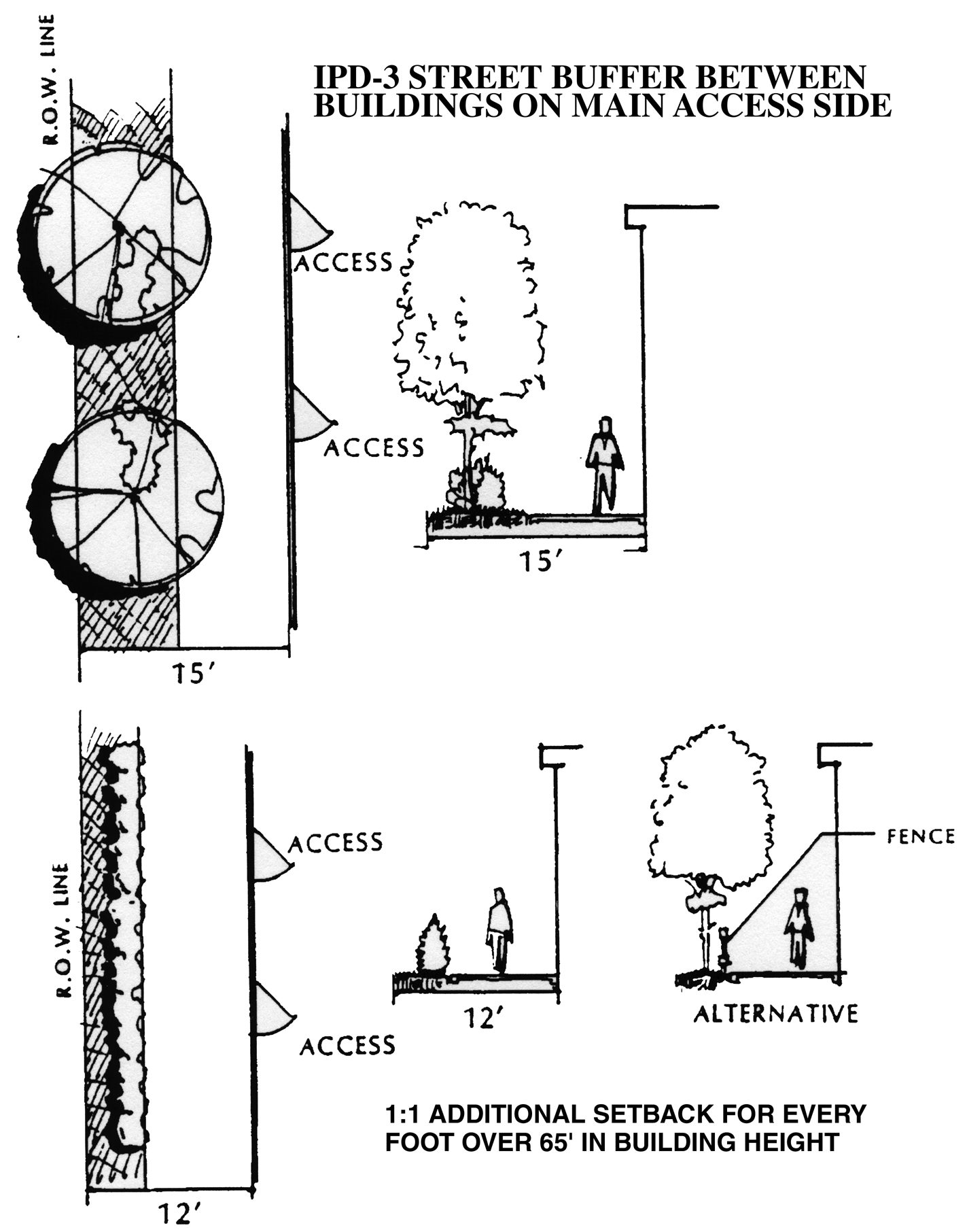
Figure 3.12, IPD-3 (UL-3) Street Buffer between Buildings on Main Access Side
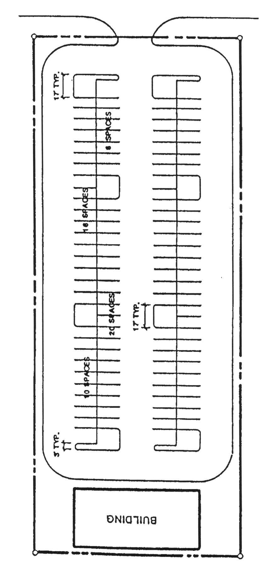
Figure 3.13, IPD-3 (UL-3) Street Buffer between Buildings Building Access to Rear or Side
J.
Commercial and Office Center Designs
1.
Mall-type Centers.
This is the preferred method of center design. In such centers, the pedestrian areas are totally separated from the automobile areas by the stores, offices or other land uses. This provides an internal pedestrian system in which motor vehicles are not permitted with access to the stores or offices primarily from the internal pedestrian system. The internal pedestrian system has definite entry points where people enter from the parking and other auto-dominated areas. The internal pedestrian system may be open to the air or fully or partially enclosed and shall equal at least ten percent of the gross floor area of the center. See Figure 3.14.
2.
Reverse Frontage Centers.
This is the second of the preferred types of arrangements of center design. It is intended to create a pedestrian-oriented streetscape and buildings that have similar architectural treatment on all four sides. The stores and offices are placed close to the street with the parking areas to the rear; in contrast to the conventional arrangement which places the buildings to the rear of the property furthest from the street. In this design type, signage can be smaller since it will be much closer to the roads. See Figure 3.15.
3.
Conventional Centers.
This is the least preferred type of arrangement of center design. The stores or offices are primarily oriented toward the street or street intersection, with parking between the street(s) and the buildings and the center's internal pedestrian system equaling less than ten percent of the center's gross floor area. See Figure 3.16.
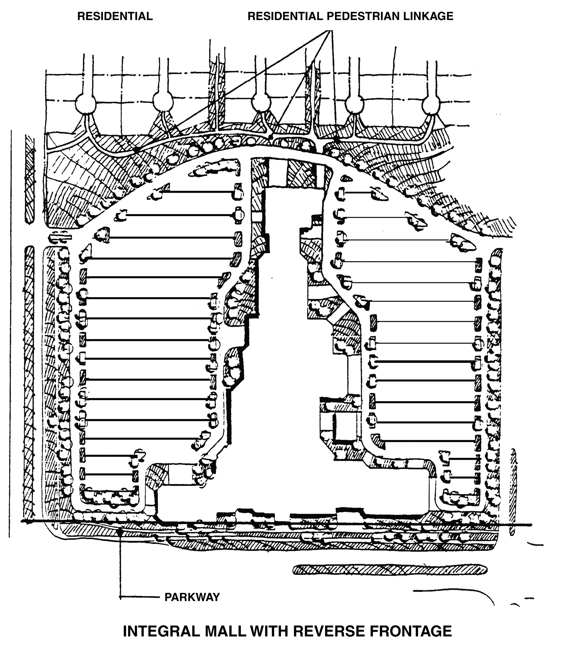
Figure 3.14, Integral Mall with Reverse Frontage
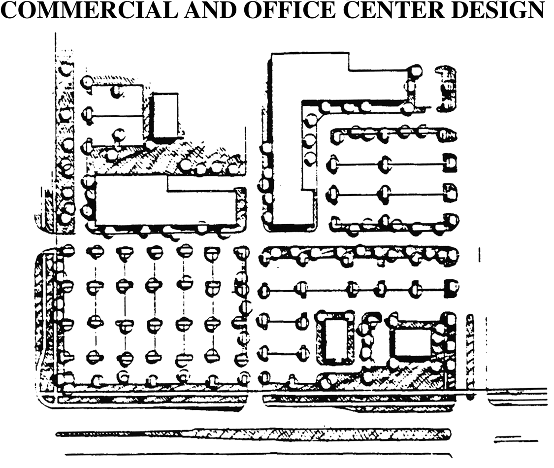
Figure 3.15, Commercial and Office Center Design
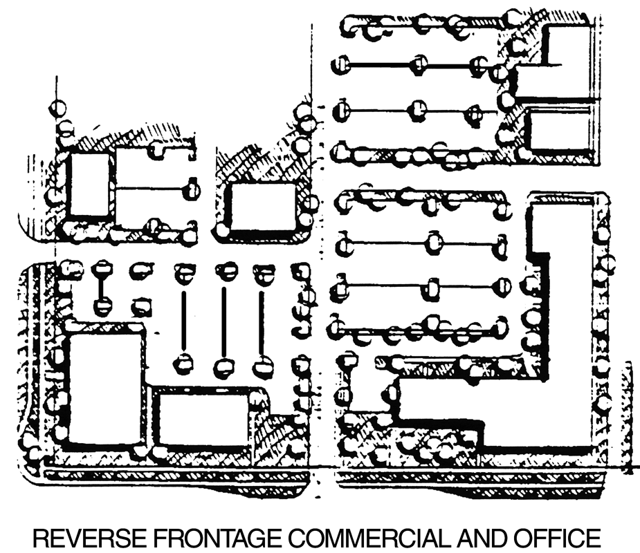
Figure 3.16, Reverse Frontage Commercial and Office
4.
Center Standards.
a.
Mall-type Centers and Reverse Frontage Centers.
(1)
Parking lots shall be landscaped in accordance with the Landscaping Regulations of this Code.
(2)
The minimum sidewalk width shall be eight feet. A total of 200 square feet of planting area containing two trees and other landscape plants shall be provided for every 80 feet of building frontage measured along the curb line. Street furniture that is of an appropriate size and configuration for the site shall be required and approved during the site plan review process. See Figure 3.17.
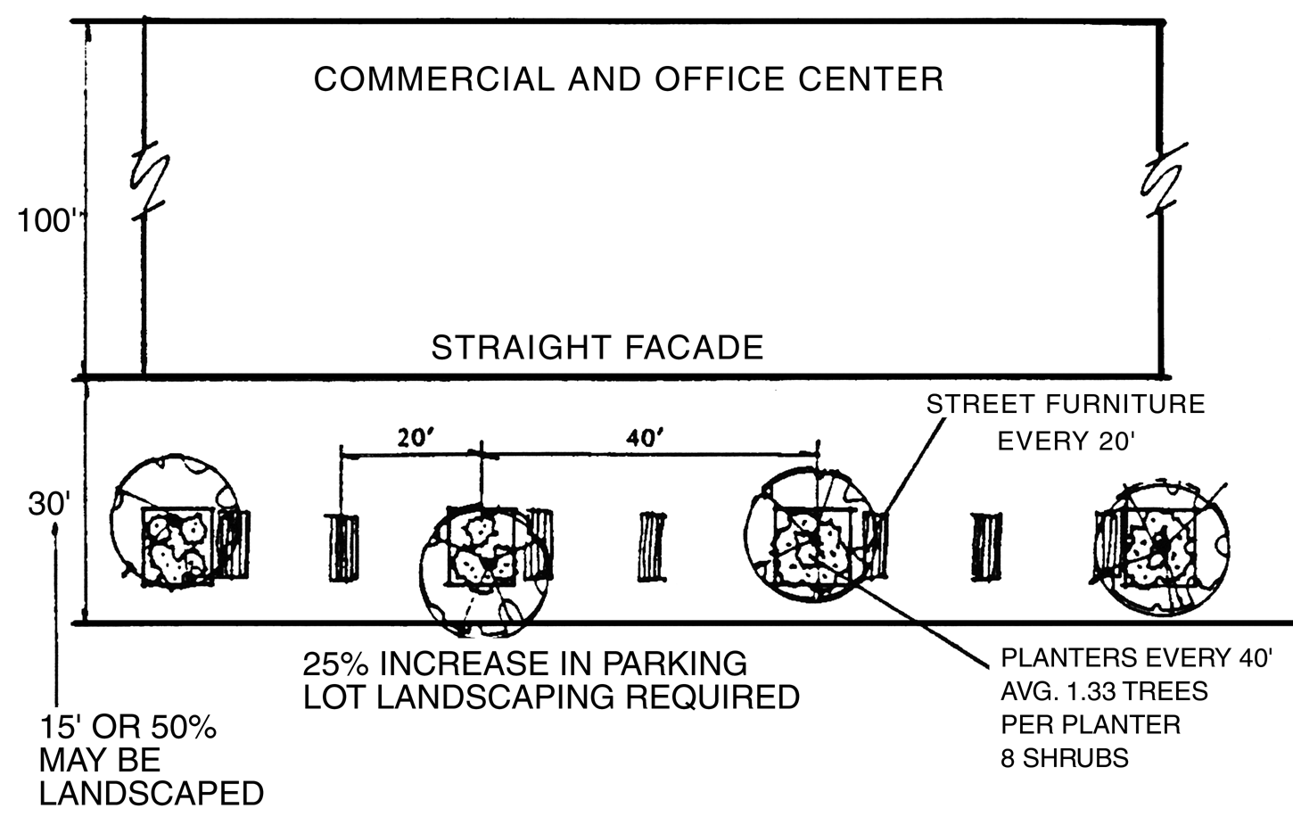
Figure 3.17, Commercial and Office Center
b.
Where the conventional center design is permitted in IPD districts, the following design and landscaping elements shall be provided:
(1)
The parking lot landscaping, including island areas and plant material, shall be increased by 25 percent above the normal parking lot landscaping requirements of the Landscaping Regulations of this Code.
(2)
Directly in front of the center structure(s), a 30-foot wide walkway shall be required. An eight feet by eight feet planting island, containing one tree and eight shrubs shall be located every 40 feet, or part thereof, along the store frontage measured along the front curb line. Two benches and one trash container shall also be located at 40-foot intervals and shall be in harmony with the overall design of the retail center. In order to accommodate more creative design techniques within the 30-foot walkway area, the pavement or sidewalk may be reduced to 15 feet provided that the remaining area is landscaped and irrigated in accordance with these regulations. In no event shall the overall walkway area be less than 30 feet in width. See Figure 3.18.
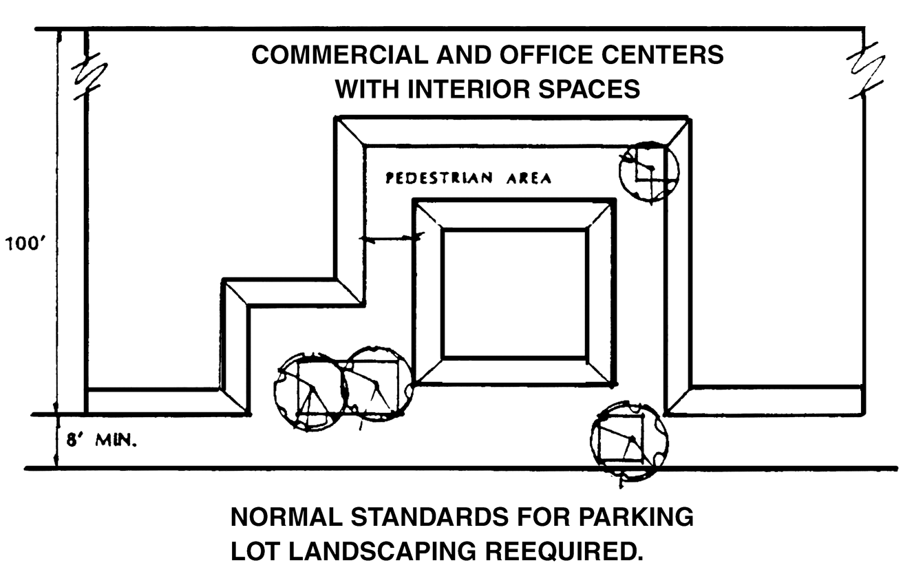
Figure 3.18, Normal Standards for Parking Lot Landscaping Required
K.
Buffering and Screening.
In order to reduce the impact of a particular land use on adjacent uses which are of a different character, density or intensity, buffers and screening shall be required in accordance with the following:
1.
The required buffer distance between the proposed land uses and the boundaries of the adjacent parcels is set out in the Buffer Matrix below. If the land next to the proposed development is vacant, the buffer required shall be determined by the existing zoning on the adjacent vacant parcel. If the adjacent parcel is vacant but is zoned for a more intensive zoning district, no buffer area shall be required of the less intensive use. The relative degree of intensity shall be determined as indicated in 6.06.05. The grouping of the zoning districts shall be as indicated in the Buffer Matrix below. The conversion of the zoning districts and the use group lists shall be as indicated in 6.06.05.
2.
The use of a landscaped hedge, berm, wall and/or screen may be determined by the developer as long as the degree of protection afforded to the adjacent use is not reduced. This applies to all bufferyards.
3.
Plant units are used to determine the varying width and planting of the bufferyards. The concentration of plant units increases or decreases as the width of the bufferyard decreases or increases. The Buffer Matrix below depicts the three alternative plant units from which developers may choose to construct their buffers. Figure 3.19 below shows the concentration of plant units required based on the width of the bufferyard. For the more intensive bufferyards, visual screening may be required. Section 6.06.03.A.5 shall apply when overhead power lines exist within the required vegetative planting areas.
4.
For example, if a developer were required to provide an F bufferyard along 400 feet of property line, the developer would have several choices. The developer could choose to provide a 15-foot wide bufferyard, thereby being required to provide three and one-half plant units for every 100 lineal feet of bufferyard or a total of 14 plant units and visual screening. The plant units used are also chosen by the developer. The developer can choose to provide 14 canopy trees, 28 understory trees, and 42 shrubs (Plant Unit Alternative 1 multiplied by 14). If the developer chooses to provide a 40-foot wide bufferyard, then a total of 12 plant units would be required, but no visual screening.
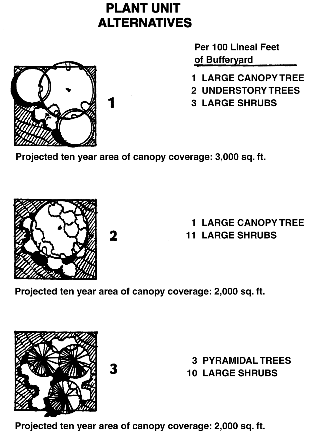
Figure 3.19, Plant Unit Alternatives
Buffer Matrix
Use Categories Abutting Use I II III IV V VI Proposed Use I. Single Family See
Section 6.06.05E F II. Two-Family and multiple family ≥ 12 du/ac See
Section 6.06.05B F III. Multiple Family >12 du/ac See
Section 6.06.05B D IV. Group 1 Uses See
Section 6.06.05A D V. Group 2 Uses E B B A 0 B VI. Group 3 Uses F F D D B 0 Note: See Table of Required Plant Units below for clarification of A F. Required Plant Units
Required Width of Bufferyard (feet) Bufferyard 15 20 25 30 40 A 0.5 0.4 0.3 0.2 0.2 B 1.0 0.8 0.6 0.4 0.4 C 2.08 1.6 1.2 0.8 0.8 D 2.7VS 3.0 2.4 1.8 1.8 E 3.75VS 3.25VS 3.2 2.4 2.4 F 4.0VS 3.50VS 5.0 4.0 3.0 KEY: VS = Visual Screening L.
Plant Materials
The following list of plant materials shall be used as a guideline to define the plant unit alternatives. Although the list may be expanded, it is intended to provide guidance in selecting predominately hardy Florida native species. Exempted trees, as listed in the Hillsborough County land alteration and landscaping requirements of this Land Development Code, shall not be considered as a plant unit alternative. Conversely, the retention of existing native vegetation shall be maximized within the proposed bufferyards. Credit shall be given for tree preservation within the proposed bufferyards.
1.
Large Trees. 8'—10' in height at time of planting. Large trees shall reach a height of at least 40 feet at maturity. The growth habit shall be described by the following categories:
a.
Large Canopy. Shall provide the maximum canopy potential by displaying a spreading growth habit.
Common Name Botanical Name Live Oak Quercus virginiana Laurel Oak Quercus laurifolia Sweetgum Liquidambar styraciflua Maple Acer rubrum Sycamore Plantanus occidentalis Elm Ulmus americana v. floridana Hickory Carya glabra Ash Fraxinus pennsylvanica Hackberry Celtis laevigata b.
Pyramidal Canopy. Provides less canopy area than large canopy trees. The growth habitat shall be a conical configuration.
Common Name Botanical Name Slash Pine Pinus elliottii Sabal Palms Sabal palmetto Southern Red Cedar Juniperus silicicola Magnolia Magnolia grandiflora Bald Cypress Taxodium distichum American Holly Ilex opaca River Birch Betula nigra 2.
Understory Trees. 6'—8' in height at time of planting. Understory trees shall reach a height of at least twenty (20) feet at maturity.
Common Name Botanical Name Dogwood Cornus florida Wax Myrtle Myrica cerifera Crepe Myrtle Lagerstroemia indica Drake Elm Ulmus parvifolia Chickasaw Plum Prunus angustifolia Ligustrum (tree form) Ligustrum lucidum Fringe tree Chionanthus virginicus Loquat Eriobotrya japonica 3.
Large Shrubs. 4'—6' in height at time of planting. Large shrubs shall reach a height of at least eight feet at maturity.
Common Name Botanical Name Silverthorn Elaeagnus Elaeagnus pungens Ligustrum Ligustrum japonicum Photinia Photinia fraseri Pfitzer Juniper Juniperus pfitzer Yaupon Holly Ilex vomitoria Palmetto Serenoa repens Viburnum Viburnum odoratissimum Pampas Grass Cortaderia selloana 
Figure 3.20, Bufferyand Example
M.
Protection of Residential Development.
Buffering and screening requirements protect residential development from adverse impacts by the more intensive urban development permitted in the IPD districts. Two types of buffers shall be used in IPD districts which abut existing residential development. The first buffer shall be a building height slope/setback which provides for additional setback protection from immediate visual, noise, dirt, and other impacts associated with different or more intensive uses. A second type of buffer shall be an intensity buffer that protects against impacts of proposed uses in the IPD districts by reducing their intensity.
N.
Intensity Buffers
The following intensity buffers shall be required in addition to the bufferyards detailed in Section 3.02.04 K.
1.
Building Height Slope/Setback Regulations.
The heights of proposed buildings adjoining residential structures shall be limited and tied to the width of the building setbacks.
a.
Next to Pre-I-75 Corridor Residential Development.
(1)
For every foot the proposed building height exceeds twenty (20) feet, an additional five feet of setback from the inside of the bufferyard shall be provided. The maximum building setback shall not exceed 500 feet. The first ten percent of the setback shall be kept in landscaped area and shall not be used for to parking or loading. The remainder of the setback may include parking and loading areas. (See Figure 3.21)
(2)
Where proposed developments are separated from neighboring residential property by an existing road (or a right-of-way), the 1:5 allowable building height line shall begin at the right-of-way centerline. (See Figure 3.22)
b.
Next to Post-I-75 Corridor Residential Development.
(1)
For every foot the proposed building height exceeds 20 feet, an additional two feet of setback from the inside of the bufferyard shall be provided. The maximum building setback shall not exceed 500 feet. The first ten percent of the setback shall be kept in landscaped area and shall not be used for parking or loading. The remainder of the setback may include parking and loading areas.
(2)
The 1:5 slope/setback shall be applied from pre-I-75 residential development only and shall not apply from residential development approved after the adoption of the I-75 Development section of the Comprehensive Plan, and from vacant residential or agriculturally zoned lands.
(3)
Where proposed developments are directly abutting a residential lot consisting of one acre or more, and the residential structure is placed at least 100 lineal feet from the existing residential property boundary, the 1:5 allowable building height line shall begin at the closest building wall of the residential structure. (See Figure 3.20)
(4)
As an alternative to strict compliance with the 1:5 slope/setback stated above, the developer may demonstrate through a cross-section drawing, that existing or increased screening will block views of the proposed building from adjoining residential structures. In this case, the developer may decrease the setbacks as shown in Figure 3.21.
(5)
In addition, in pre-I-75 Corridor residential areas that are in obvious transition, the developer may demonstrate, through prior changes in zoning, that the development trend for the pre-I-75 Corridor residential area is away from residential development. In this case, the slope/setback and the following intensity feathering may be reduced or deleted by the Administrator.
2.
Intensity Feathering.
a.
To protect pre-I-75 Corridor residential development that is basically suburban in nature from urban forms of development permitted in the three IPD districts, a feathering of the densities shall be required. See Figure 3.22. These densities shall be altered by two factors: (1) the distance between the proposed development and existing residential structures, and (2) the density of the existing residential structures. For the purposes of defining the intensity limits, a "ring" shall extend out 350 feet from existing residential development when the adjacent existing residential development is less than six dwelling units per acre in density. The feathering of intensity shall not apply to residential developments consisting of six units per acre or greater.
b.
Intensities for all proposed uses within the ring shall be limited to a maximum FAR of .30. Where a street exists as the border between the two uses, then the depth of the intensity ring shall be reduced by half the width of the right-of-way.
O.
Protection of Visibility at Intersections
Protection of visibility for vehicles, cyclists and pedestrians shall be as generally provided in 6.04.03 F.
P.
Access
1.
Access to Collector Roads.
If property fronts on both a collector and an arterial street as defined under the Hillsborough County Functional Classification System, primary access shall be from the collector. If the need to create a new collector between two existing collectors on an arterial roadway can be demonstrated (i.e. in order to maintain traffic flow at peak hour Level of Service D on arterials and Level of Service C on specific State arterials), then a new collector shall be permitted in accordance with the Interstate-75 Corridor Plan and (2) below.
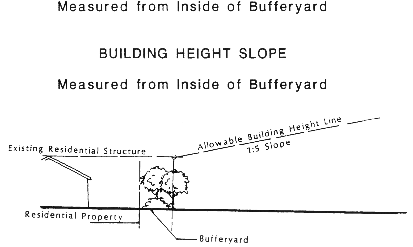
Figure 3.21, Building Height Slope
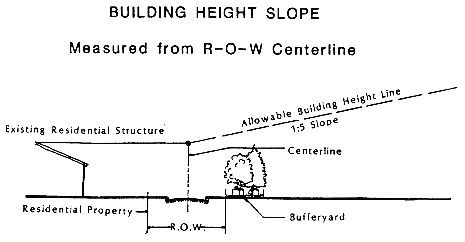
Figure 3.22, Building Height Slope
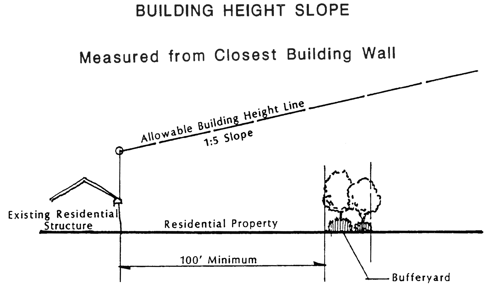
Figure 3.23, Building Height Slope
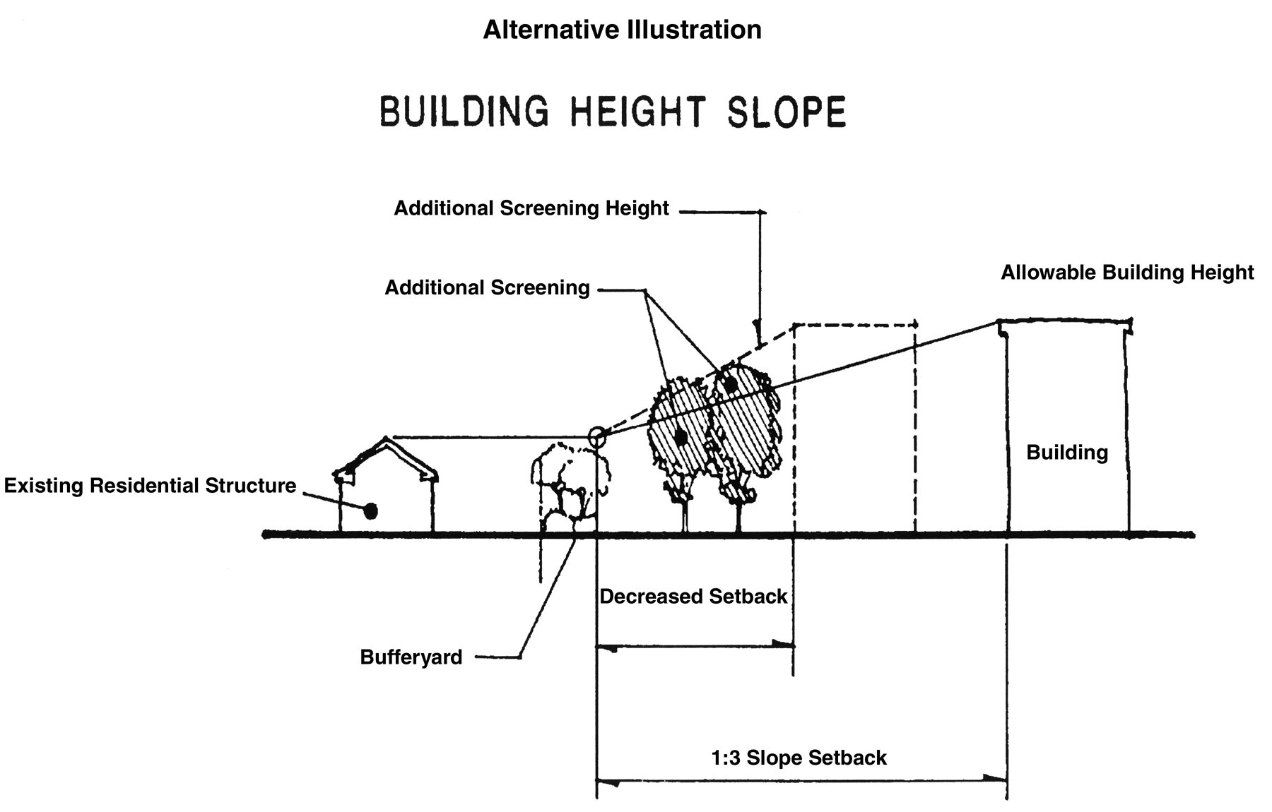
Figure 3.24, Building Height Slope
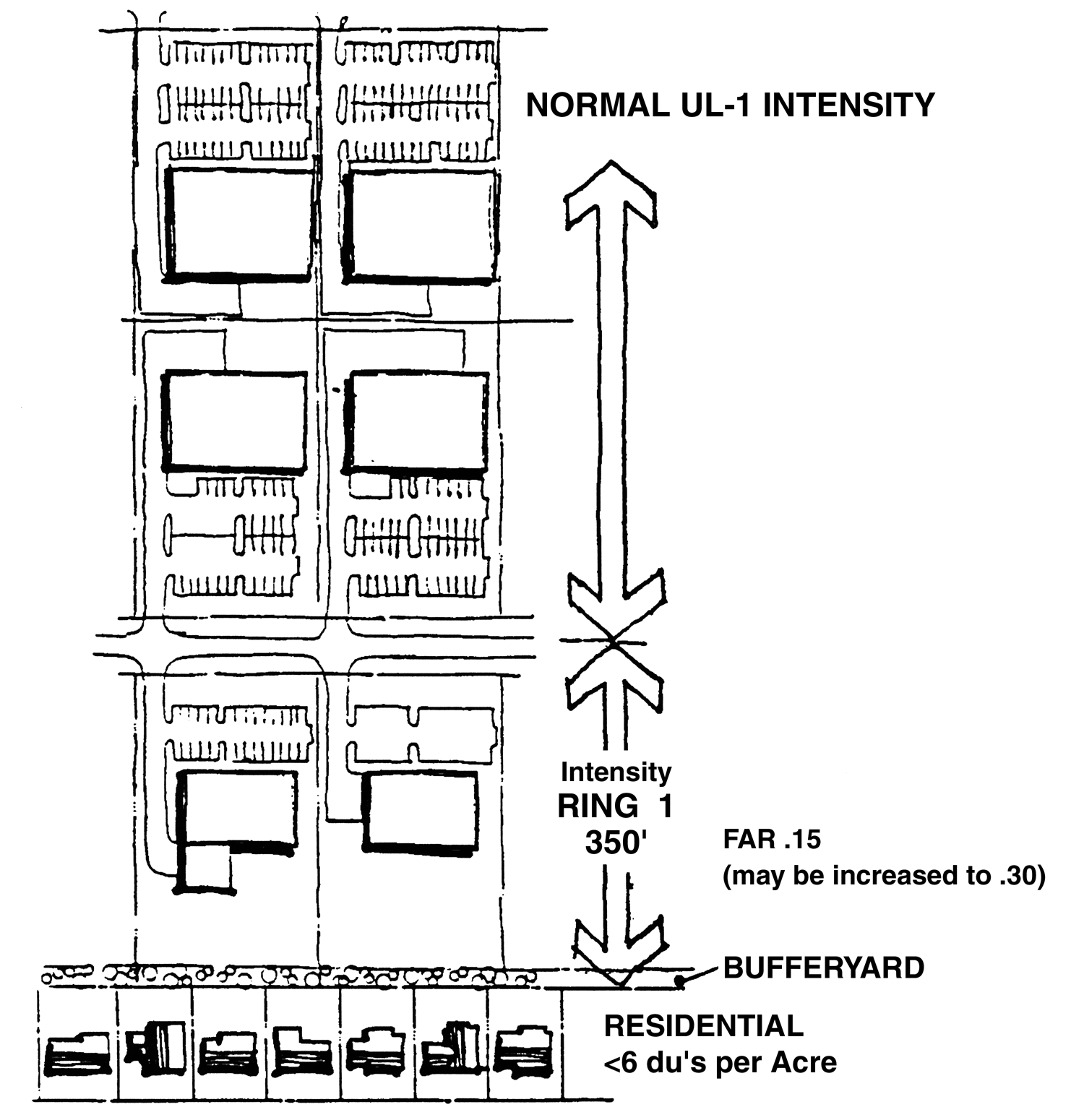
Figure 3.25, Feathering Illustration
2.
Collector Spacing.
The minimum spacing between direct access collector roads, as defined under I-75 Corridor Plan, is as follows unless otherwise approved by County Engineering Staff and/or FDOT:
Collector Spacing
Full Movement Intersection IPD-1 2,640 ft. (½ mile) IPD-2 & IPD-3 1,320 ft. (¼ mile) Median Openings Between Collectors For all IPD Districts ft. Right Turn Only Intersection For all IPD Districts 330 ft. 3.
Temporary Access.
a.
The County and/or the FDOT may permit a temporary access to an arterial street, as defined under the I-75 Corridor Plan, for a developing property that does not meet the criteria in 1 and 2 above when the property has no other access. All properties issued a temporary access shall comply with the Internal Access Roads standards below.
b.
The temporary access shall exist only as long as the property remains without other access options. As soon as a permanent access can be established in accordance with the requirements of this Code, or as soon as a better temporary access can be obtained, the County and/or the FDOT shall require the temporary access to be closed. The County and/or FDOT shall not be held liable for any damages sought by businesses who claim undue hardship from temporary access closure. The closure of the temporary access and the planting of the area in accordance with the land alteration and landscaping requirements of this Land Development Code shall be the responsibility of the landowner. If the landowner fails to begin work on the closure within 60 days of written notification by certified mail, or otherwise fails to proceed to complete the closure, the County may enter upon the property and accomplish this task, and lien the property to recover all direct and administrative costs of such work. A statement authorizing this shall be contained on the final plans for the development.
4.
Internal Access Roads.
a.
Developments fronting on a collector or an arterial street, as defined by the I-75 Corridor Plan, shall participate in developing an internal access road system serving the entire block in an effort to discourage curb cuts and intersections with local streets on planned arterial roadways and also to restrict direct access to arterial roadways from development projects when access can be provided through a collector facility. The County in cooperation with the FDOT, where appropriate, shall develop plans designating the method of internal access for all property between the developer and any public roadway. The County shall send copies of the plan to all affected landowners to inform them of the plan. Any landowner may request a hearing on the plan if they have objections. The approval of all developments shall be contingent upon the internal access roads being built as shown on the approved plan as they provide access to adjoining properties.
b.
Three types of internal access roads shall be permitted: frontage roads, reverse frontage roads, and collector roads. These types of internal access roads may be used alone or in combination with each other. See Figure 3.26.
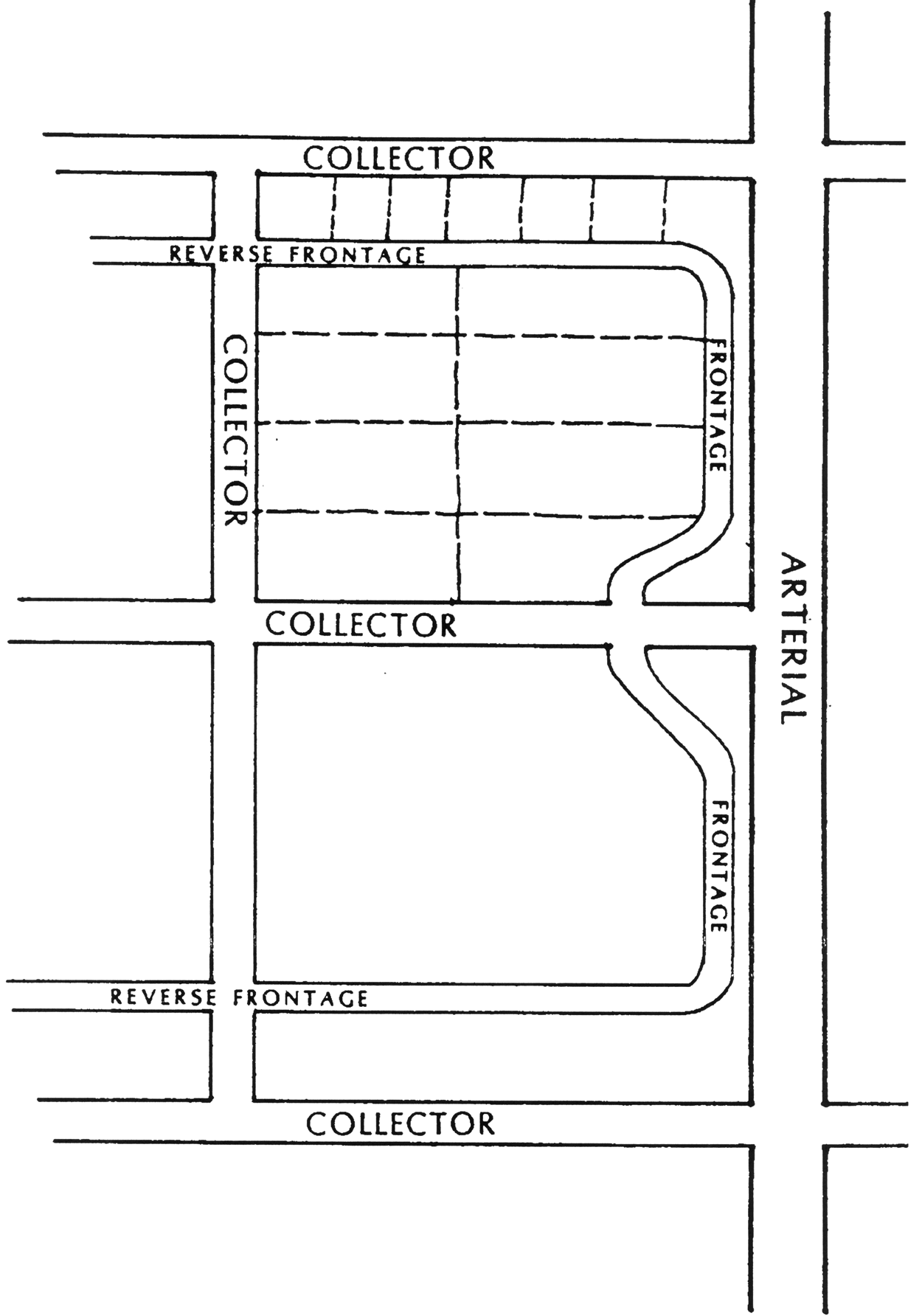
Figure 3.26, Internal Access Roads
5.
Right Turn Movements.
All right turn only intersections shall be restricted to right turn in and right turn out movements. No median breaks shall be permitted at these intersections. Further, each right turn in/right turn out intersection shall provide an appropriate stacking lane and acceleration/deceleration lanes. The exact length of the stacking lane and any other geometric requirements shall be determined by County Engineering and/or FDOT staff after an Engineering Study is completed by the developer.
Q.
Relation to Major Transportation Facilities
1.
Long Range Transportation Plan.
Because of the size and intensity of the Urban Level Categories in the Interstate-75 Corridor, the County shall undertake to develop an Interstate-75 Corridor Plan to be included in the Transportation Element of the Hillsborough County Comprehensive Plan. The Corridor Plan shall demonstrate an adequate arterial and collector support system for the Interstate-75 Corridor. Until this Plan is completed, the current MPO Long Range Transportation Needs Assessment Map in effect at the time of application for development approval, shall be used as guidelines for designating arterial and collector roadways.
2.
Rights-of-way and Cross-sections.
a.
All roads designated as arterials on the County's Interstate-75 Corridor Long Range Transportation Plan shall require rights-of-way capable of supporting the installation of a six-lane roadway with median. Right-of-way requirements shall be consistent with the adopted long range transportation plan and cross-sections shall comply with the standards of the Engineering Services Section and/or the FDOT. It should be noted that once the I-75 Corridor Long Range Transportation Plan is adopted, the cross-sections shown in Figures 3.27 to 3.31 may need to be revised to reflect the cross-section needs of the plan.
b.
Each development adjacent to a roadway(s) classified as an arterial or collector shall either dedicate the appropriate right-of-way as indicated in Tables 4 through 8 or set back all development activity from the portion of the site which will be needed for future right-of-way.
c.
The following cross sections are provided as a guide to implement the I-75 Corridor Comprehensive Plan policies and may be modified subject to the provisions of 3.02.02 C.
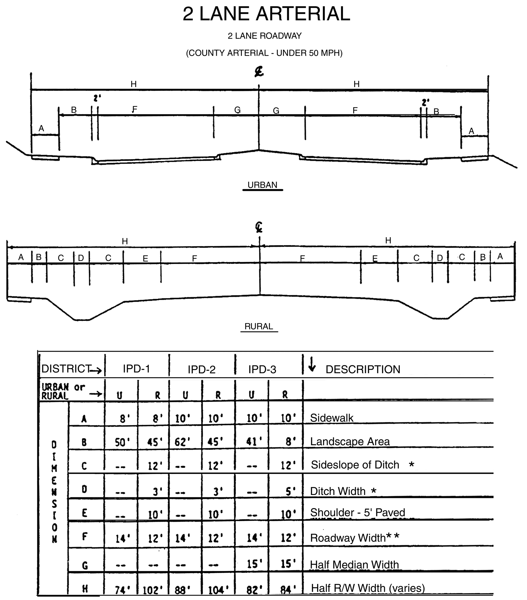
Figure 3.27, X Sections (2 Lane Arterial)
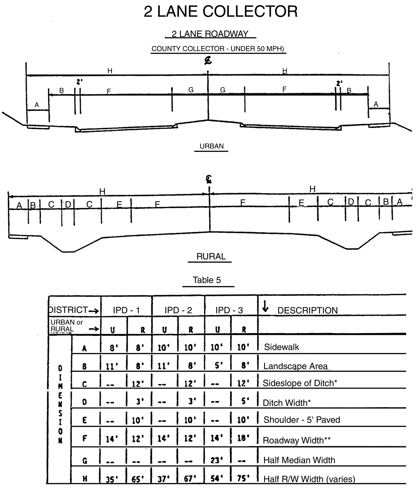
Figure 3.28, X Sections (2 Lane Collector)
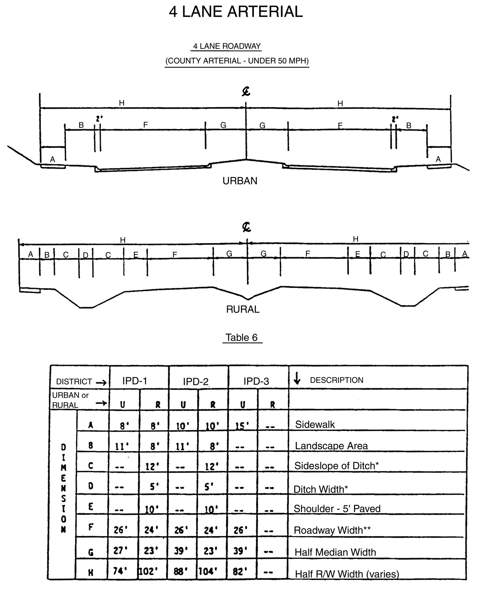
Figure 3.29, X Sections (4 Lane Arterial)
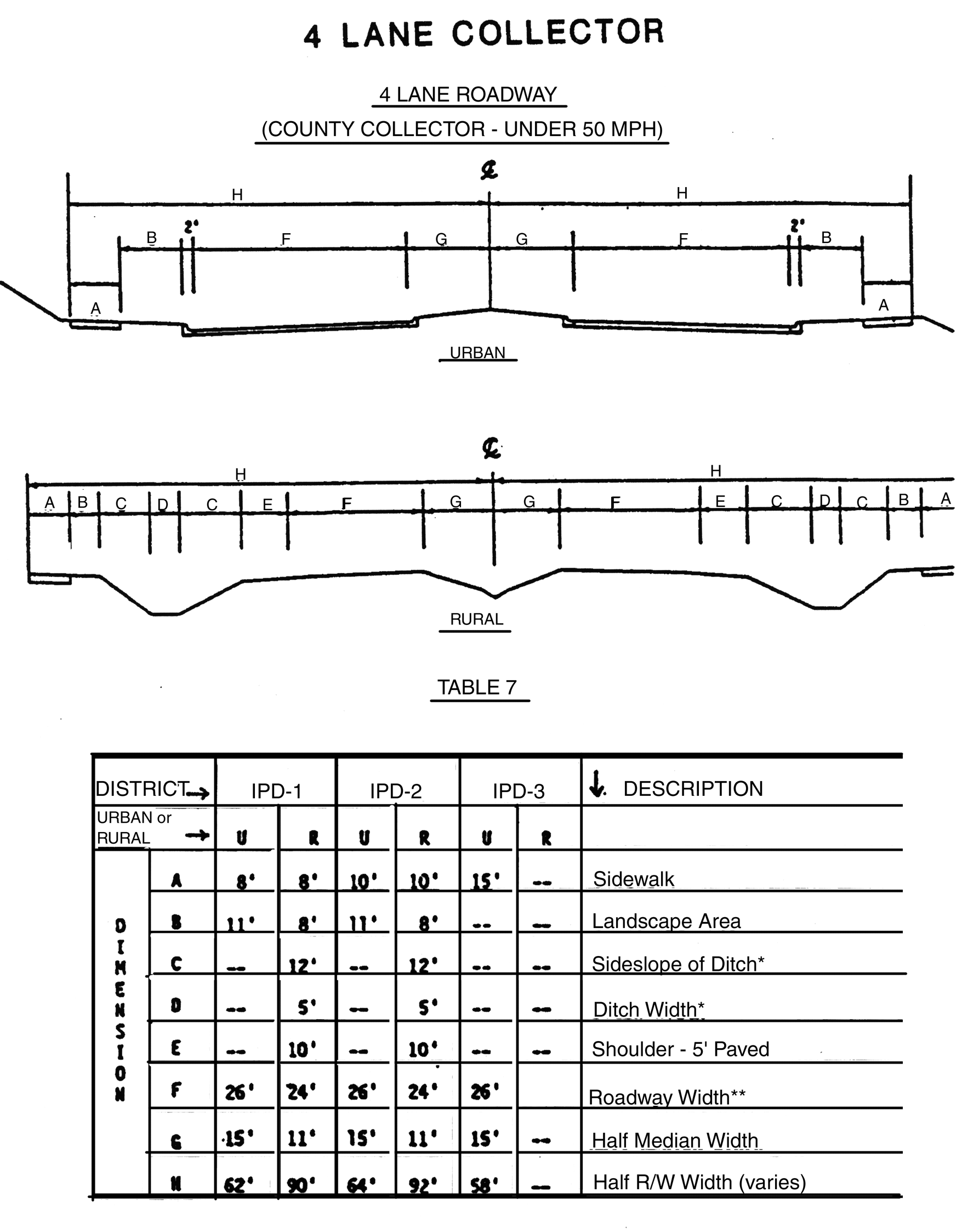
Figure 3.30, X sections (4 Lane Collector)
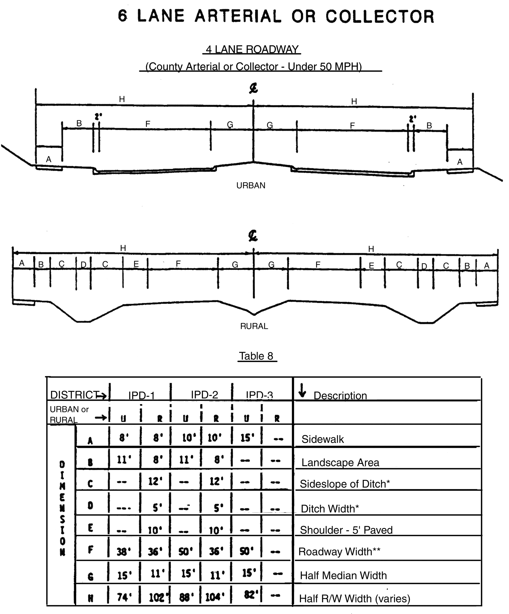
Figure 3.31, X sections (6 Lane Arterial or Collector)
R.
Transportation Standards: Roadway Capacity Analysis
1.
The purpose of the transportation analysis shall be to demonstrate that sufficient roadway capacity exists on roadways impacted by the development to support the remaining unconstructed portion of the development without violating the level of service standards presented herein. The analysis shall include traffic from existing developments and developments under construction which impact the same roadways.
2.
No IPD development shall be permitted that would result in a reduction of the impacted road network's level of service (LOS) below the LOS standard. The LOS standard for all roadways in the I-75 Corridor shall be as stated in the update of the Traffic Circulation Element of the Comprehensive Plan for Hillsborough County. Therefore, all IPD developments generating over 100 vehicle trips per day, shall be required to submit a road capacity analysis pursuant to the above criteria. The LOS approved in the Comprehensive Plan shall be the standard applied in this Article.
3.
The above criteria may not apply if it is determined pursuant to the procedures set forth in Div. 1.8 that a particular project has "vested rights" with respect to transportation. In addition, those phases of Developments of Regional Impact specifically approved prior to the February 14, 1989 shall not be subject to the transportation analysis and service level requirements contained herein. Development of those phases of these projects shall proceed in accordance with the transportation mitigation conditions contained in the development order.
4.
IPD district road capacity analyses shall determine the amount of development to be permitted based on available roadway network capacity and the necessitated roadway improvements to mitigate the development's impact. Additional increments of development may be approved concurrent with roadway improvements sufficient to provide the necessary capacity.
5.
Prior to the issuance of building permits (if more than two years following zoning approval or if more than two years since the last transportation analysis was submitted) the developer shall provide a transportation analysis which presents the anticipated transportation impacts from the development or portion of the development under consideration. Building permits shall be issued only if it is shown that sufficient roadway network capacity to serve the project is available, or shall be provided by the developer. The developer shall indicate on each detailed site plan the date of the last transportation analysis submitted along with verification that there is sufficient roadway network capacity to serve this portion of his development.
S.
Nonmotorized Circulation System
1.
IPD Nonmotorized Circulation System.
All IPD Districts shall provide an on-site Non-motorized Circulation System that shall connect the following major components of the development:
a.
Pedestrian Facilities
b.
On-site Structures and Uses
c.
Bicycle Trails
d.
Internal and External Road Systems
e.
Abutting Properties
f.
Transit Facilities
2.
On-site Pedestrian Facilities Required by IPD Districts.
a.
All IPD districts shall have on-site pedestrian trails and/or sidewalks which connect on-site structures and uses with the street sidewalks along the internal and external roads as described in 3.02.04 P.
b.
For IPD-2 and IPD-3 districts, a grade separated pedestrian crossing system shall be required at the locations determined in the Pedestrian Circulation Plan. The Pedestrian Circulation Plan shall be developed upon completion of the I-75 Corridor Long Range Transportation Plan. The Pedestrian Circulation Plan will establish locational and warrant criteria and the funding mechanisms for grade separated pedestrian crossings.
3.
On-site Bicycle Facilities Required by IPD Districts.
a.
All IPD-1 districts shall have off-street bicycle trails linked with pedestrian trails and sidewalks. Where infeasible due to the size and type of the project, the required sidewalk and on-road bicycle facility will assure continuity of the bicycle trail with abutting properties.
b.
All IPD-2 districts that adjoin an IPD-1 district or an IPD-2 district project that have incorporated a bicycle trail, shall incorporate a bicycle trail into its on-site Non-motorized Circulation System. All other IPD-2 district developments shall have the option of providing off-street bicycle trails.
c.
Off-street bicycle trails are not appropriate, in the IPD-3 district. On-street bicycle accessibility will be required in transportation requirements per 3.02.04 P.
4.
Bicycle Parking Areas.
a.
All IPD districts shall provide bicycle parking areas that shall be accessible to on-site bicycle trails and facilities, and on-site structures and uses. Developments with multiple structures and uses shall provide bicycle parking in close proximity to all of the specific use areas. Bicycle parking spaces shall be provided based on a ratio of one bicycle parking space per each twenty required motor vehicle parking spaces. The provision of bicycle parking spaces shall reduce the number of required vehicle parking spaces pursuant to 6.03.00. If the percentage required is less than two bicycle parking spaces, a minimum of two bicycle parking spaces shall be provided. Residential developments shall only be required to provide bicycle parking areas in conjunction with on-site common use and recreational areas such as clubhouses, parks and pool areas.
b.
Bicycle Parking Areas, when not paved, may be included as part of the required open space.
5.
Employee Showers.
To encourage walking and bicycling as commuting modes in IPD districts, it is recommended that shower facilities for both sexes be provided for all developments with 50 employees or greater.
T.
Mass Transit.
The following criteria and standards for rail and bus transit shall be incorporated into the detailed site plans for all IPD district developments.
1.
Rail Transit.
a.
Rail transit facilities shall be built by Hillsborough Area Regional Transit Authority (HART) or the appropriate designated agency. The provision of rail and bus facilities at stations may be in conjunction with developers or property receiving a node designation and shall ensure full pedestrian access to the transit station. All developments on bus routes shall make provision for either a bus stop or ensure the best possible pedestrian access to the transit station.
b.
Once a rail transit station location is identified, the County shall designate it as a transit node. At the time of designation, the County Administrator or other appropriate agency shall designate the pedestrian connector routes providing access to the transit station and shall encourage higher intensity uses to locate in close proximity to the transit station. The following criteria shall be used by staff to designate the pedestrian routes:
(1)
Pedestrian routes shall be generally radial from the rail transit station and shall provide for the shortest route that can be achieved given a generally rectangular road and property base.
(2)
A bus stop shall be in a readily available position for use by pedestrians and rail transit users.
2.
Bus Transit.
a.
Bus routes shall be established by HART but may not be present when development first begins in an area. All developments on bus routes shall make provision for either a transit stop or ensure the best possible pedestrian access to a transit stop. All residential developments containing more than 200 dwelling units, and all non-residential developments having more than 200,000 square feet shall make provisions for a transit stop as part of their application for an IPD district. The County and HART will determine the timing for installation of the transit stop at the rezoning stage. Such facilities when built in accordance with the provisions of this Section, shall be counted as a part of the project's total open space.
b.
During detailed site plan review, the County shall seek a recommendation from HART in approving the location of a transit stop. The following criteria shall be used in reviewing the transit stop location.
(1)
The transit stop shall be in a high activity area and well-lighted.
(2)
Stops should be located on collector and arterial roads near the center of population of residential or employment areas. In retail areas, locations near the anchor tenants are preferred. An access easement agreement shall be provided to HART, when a transit stop provided on private property requires access across private property.
c.
All transit stop facilities shall be designed to insure the safe movement of pedestrians and the handicapped.
d.
Minor transit stops shall be designed as follows unless otherwise determined by the County and HART:
(1)
Each stop shall have the following components: shelter, seating, landscaping, lighting, phone, information, water fountain, and waste containers.
(2)
Shelters shall meet HART design standards. Stops with more than one bus likely at a time, or service more than four times per hour shall provide additional shelters as requested by HART.
(3)
Shelter design may be coordinated with the surrounding development or the separate shelter may be eliminated where the architecture provides for similarly protected space that is suitable for waiting out of inclement weather throughout the transit service period as approved by the County and HART.
(4)
Seating shall be provided both within the shelter and with suitable street furniture outside the shelter in areas that are at least partially shaded. At no time shall the street furniture contain commercial messages.
(5)
Landscaping shall be provided in the form of planters or other appropriate landscaping devices and shall include shaded seating areas.
(6)
Access and internal road geometrics within a development which provides a bus stop shall accommodate a 12.5-foot wide by 40-foot long advance design coach.
(7)
A phone booth, routing and use information displays shall be provided in the development to assist the user in getting to destinations easily.
(8)
Pedestrian paths shall be designed to move the transit users to their final destinations through pedestrian walks or precincts that are well lighted and aesthetically pleasing.
(9)
Where transit stops are located adjacent to arterial and collector roadways, the developer shall provide bus pullout bay, designed in accordance with the design standards of the County, HART and FDOT, where appropriate.
(10)
Figure 3.32 provides an example of a minor transit stop design.
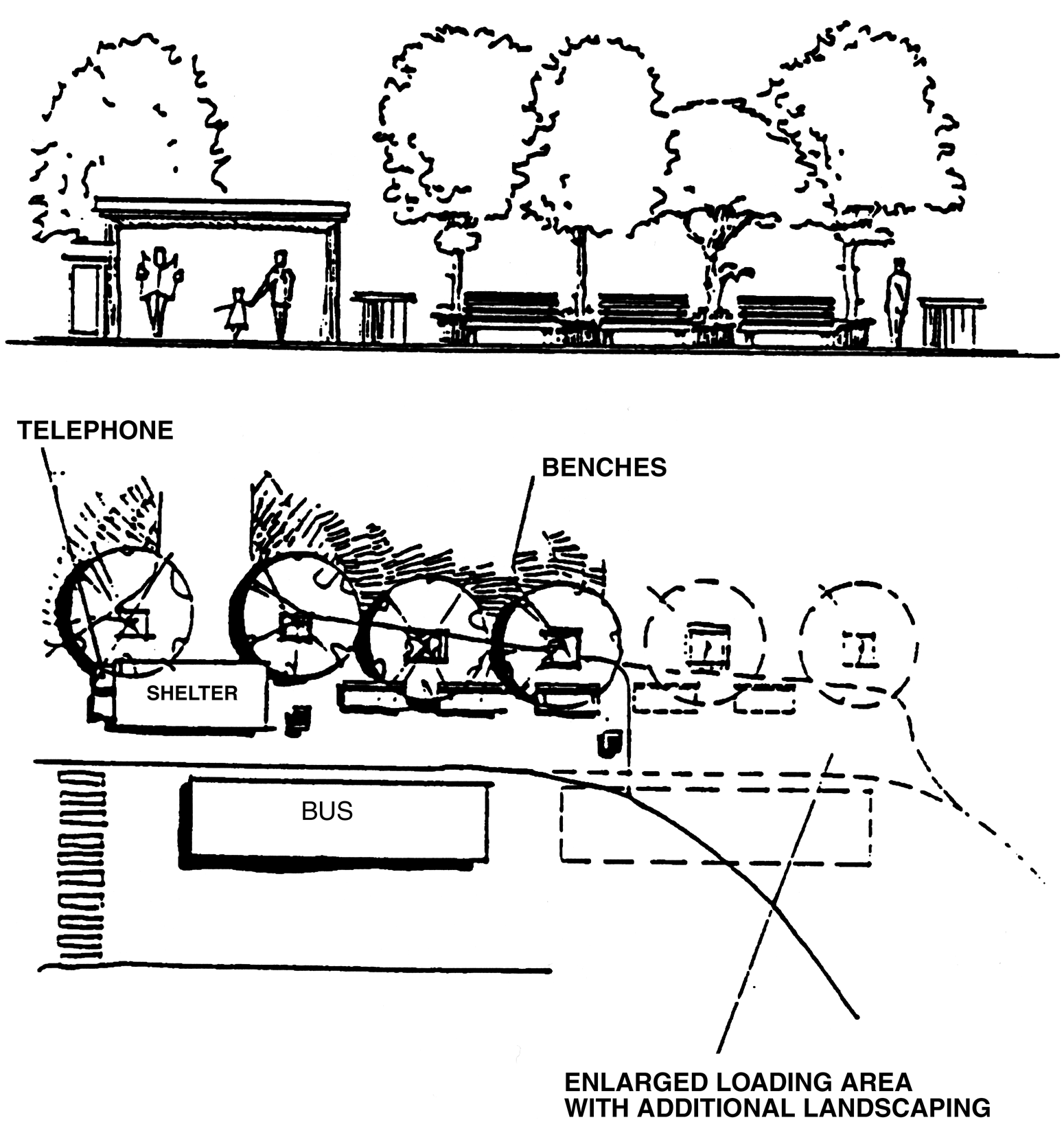
Figure 3.32, Minor Transit Stop Design
e.
Residential developments in the IPD-1 and IPD-2 districts of more than 2,000 units shall propose to dedicate a Park-n-Ride facility site as part of their application for an IPD. During detailed site plan review, the County and HART shall determine the need for such facility and shall approve, if appropriate, the location and timing of the Park-n-Ride facility site. The construction of the Park-n-Ride facility will be done by HART or as negotiated with the developer at the time of rezoning.
f.
All commercial (retail) development having more than 750,000 square feet and mixed use developments containing over 500,000 square feet of commercial space (retail) shall propose a major transit stop as part of their application for an IPD development. Major transit stops shall be designed as follows unless otherwise determined by the County and the Hillsborough Area Regional Transit Authority. (See Figure 3.33)
(1)
All standards for minor transit stops as designated in 3.02.04 T.
(2)
The major transit stop shall be provided adjacent to a main entrance in the case of a retail mall or near an anchor tenant in other cases.
(3)
Developers shall provide separate bus loading/unloading areas segregated from automobile traffic. This loading/unloading area shall be designed to accommodate a minimum of three buses, the actual number to be agreed upon by the developer and HART prior to the time of detailed site plan approval with all disputes to be settled by the County.
(4)
A bus staging area where buses stop to load and unload passengers shall be provided on site, the location of which shall be agreed upon by the developer and HART prior to the time of detailed site plan approval, with all disputes to be settled by the County.
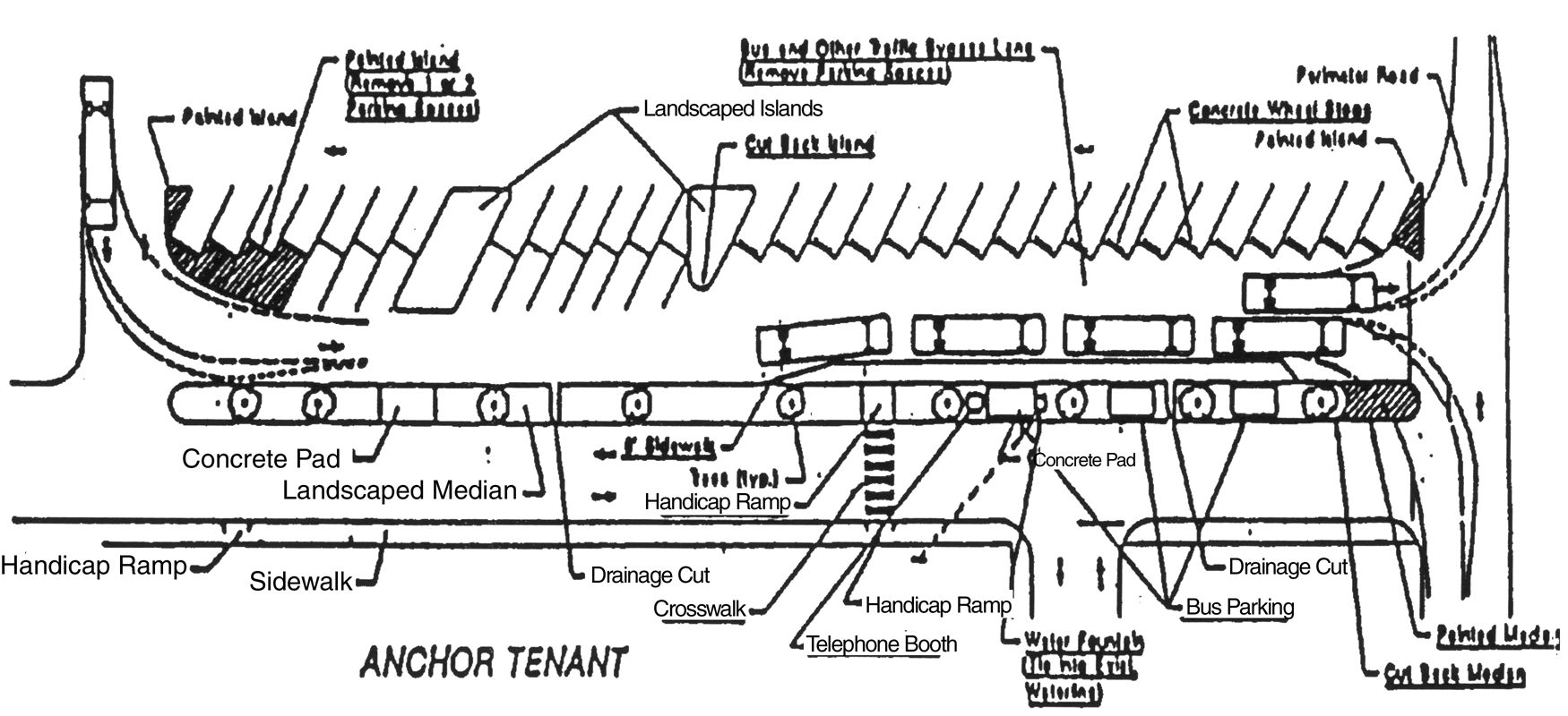
Figure 3.33, Major Transit Stop Design
U.
Outdoor Lighting
1.
Outdoor lighting shall be provided in all developments that do not require street lights. Outdoor lighting shall be located so as to illuminate the project as necessary to provide safe passage within the development but the source of the light, such as the bulb or filament, of outdoor lighting fixtures shall not be directly visible from property outside the zoning lot on which it is located.
2.
An exterior lighting plan shall be required for all exterior lights provided in an IPD district. The exterior lighting plan will demonstrate that overflow lighting does not extend beyond the property line and that a safe environment is created. All developments shall provide sufficient illumination for pedestrians and motorists to perform their normal activity within the development. Lighting shall be provided is a manner that does not pose a nuisance or unnecessary glare to motorists and pedestrians or to adjacent properties. The lighting provided within developments shall meet the requirements and recommendations of the most current standards as adopted by the Illuminating Engineering Society.
V.
Underground Utilities
Electrical distribution with the exception of circuit feeder or larger lines and telephone service lines shall be placed underground in all IPD Districts that are in an area served by underground utilities and whenever possible in other areas.
W.
Off-Street Motor Vehicle Parking and Loading Requirements
1.
Off-street motor vehicle parking and loading shall be as required by 6.03.00. Off-street motor vehicle parking and loading shall be provided such that location and design is appropriate to the needs of occupants and users of the district and protection of adjacent property from adverse effects. No space designated as a required off-street parking space for the general public shall be used as an off-street loading space or maneuvering room for vehicles being loaded or unloaded.
2.
If loading, waste storage facilities, or other facilities are located on the side of the building facing residential development, then these areas shall be fully enclosed to protect adjoining residents from having to look at the mechanical portions of the nonresidential development. See Figure 3.34. The actual dimensions of the space should be adequate to handle all required loading areas and waste storage. The minimum size shown is adequate for trucks of less than 18 feet and County garbage trucks. The County may require evidence on the maximum size of delivery trucks.
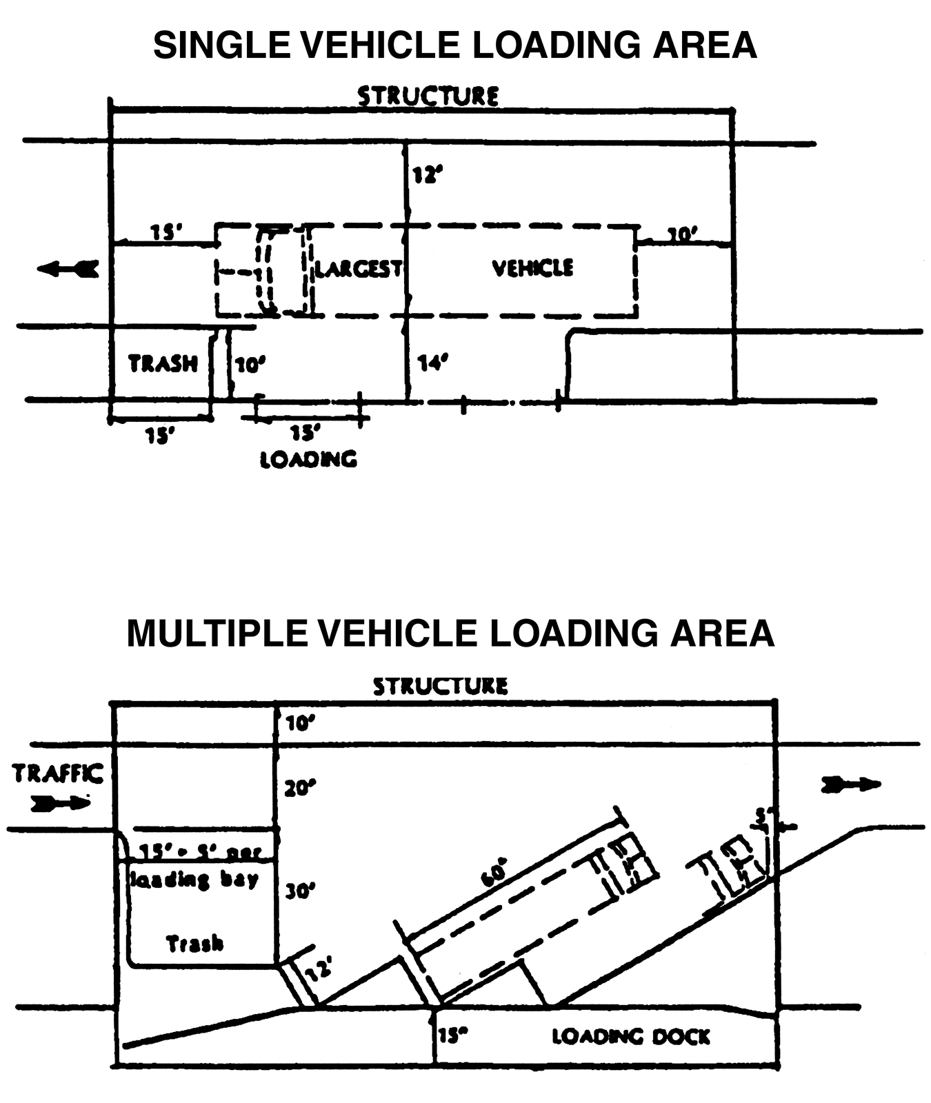
Figure 3.34, Loading illustration
X.
Exterior Storage Yards
Exterior storage yards may be located between new buildings and residential areas only if they are enclosed with a masonry wall or berm wall of at least six feet in height, and the materials stored shall not exceed a height or storage height of more than six feet. The walls shall be landscaped in accordance with this Section, in addition to any other landscaping requirements of this Land Development Code.
Y.
Riverine Corridor Overlay (RCO) Restrictions.
1.
For any land within 50 feet landward of the EPC wetland jurisdictional line where this line runs parallel to the center line of rivers and creeks designated Riverine Corridor Overlay (RCO) District, or within 100 feet of the mean and ordinary water line of such rivers and creeks, whichever is greater, the existing natural plant community vegetation including understory vegetation shall be retained, except for removal of vegetation which is necessary for:
a.
Access to and immediately around proposed structures or other improvements,
b.
Limited construction of sidewalks, paths, or trails (impervious surfaces not to exceed ten percent of the area),
c.
Picnic facilities, boardwalks, or other structures for passive recreation requiring minimal disturbance of the vegetation,
d.
Utility transmission lines if no public easement is required or if the easement is of such a size and location as to have a minimal impact on the vegetation,
e.
Construction of improvements within a road right-of-way,
f.
Construction of stormwater conveyances or outfall facilities.
2.
If it is demonstrated that no beneficial use of the property is possible without removing the natural plant community vegetation for activities other than those allowed above, the developer shall mitigate the adverse impacts to wildlife habitat, native vegetation, and natural stormwater filtration systems by preservation of another area containing a natural plant community or communities, preferably on-site and in proximity to the riverine system. This would be in addition to any other requirement for preservation of environmentally sensitive areas or provision of open space.
3.
If the above mitigation strategy is not feasible, then the developer shall choose one of the following alternatives:
a.
An increase in the percentage of required on-site native plant landscaping specified in this Land Development Code for land alteration and landscaping minimally equal to the percentage of natural plant community vegetation to be removed to obtain beneficial use of the parcel. Preferably, the additional native plant landscaping should be planted in proximity to the riverine system; or,
b.
A contribution to an established land conservation program in Hillsborough County, in accordance with the program's qualifying criteria.
c.
Fencing shall be prohibited within the 50-foot setback of the EPC jurisdictional line of rivers and creeks in designated RCO districts or within 100 feet of the mean and ordinary high water line of such rivers and creeks, whichever is more restrictive.
(Ord. No. 01-30, § 2, 11-15-01; Ord. No. 08-29, § 2, eff. 2-1-09; Ord. No. 14-3, § 2(Exh. A), (Item IV-A), (13-0719), 1-30-14, eff. 2-6-14)