 |
Hillsborough County |
 |
Land Development Code |
|
Article III. SPECIAL DISTRICTS |
|
Part 3.01.00. SPECIAL PUBLIC INTEREST DISTRICTS |
§ 3.01.06. SPI-NDM: North Dale Mabry Overlay District
A.
Generally
The intent of the North Dale Mabry Overlay District is to plan for future growth along North Dale Mabry Highway in an area located north of Van Dyke Road and south of the Pasco County line. This Overlay District prohibits the expansion of the strip commercial development pattern and preserves the integrity of the transportation system by identifying appropriate locations for activity centers to service the surrounding residential communities. The primary objectives are to provide a comprehensive pedestrian system and a quality view from Dale Mabry Highway along with the maintenance of this highway as a smoothly functioning arterial highway. The plan calls for the development to provide a parallel access highway system to increase capacity and control turning movements. The second element is a parkway 40 feet in width along the outside of the access road in which the pedestrian link will be provided.
B.
Use Permitted
Uses permitted shall be those of the underlying residential zoning, except that commercial uses may be located in activity centers as shown in the North Dale Mabry Corridor Plan adopted by resolution R89-0319 and shown in Figure 3.1. Office development may also be permitted provided it meets the locational criteria and conforms to the Land Use Element of the Comprehensive Plan.
C.
Activity Centers
Activity centers permit any of the uses in the underlying commercial zoning. Activity centers shall provide a comprehensive pedestrian system which shall include the 40-foot parkway buffer in either of the two forms shown and a linkage to the shopping areas and any office areas. The development shall use one of the four forms described in paragraphs 1 to 4 and Figures 3.2 through 3.5 below.
1.
Integral mall with direct pedestrian linkage to the parkway and to residential areas.
2.
Commercial and office complexes built to the average build line, where the pedestrian walk in the parkway buffer is increased in width to eight feet and located on the property line to provide direct access to stores or offices. Pedestrian breaks which permit access from the parkway to the opposite side of the buildings shall be no more than 200 feet apart along the stores or offices.
3.
Commercial and office complexes with interior spaces and pedestrian connections to the parkway for each development or every 720 feet, whichever is greater.
4.
Conventional commercial and office center with a pedestrian walkway in front, and pedestrian connections to the parkway for each development or every 600 feet, whichever is greater.
5.
Neighborhood Activity Center - In addition to the requirements of Section 3.01.0.C development shall be in accordance with the following.
Special Requirements/Provisions:
a.
Permitted uses shall be CN uses as provided in Section 2.02.02 of this Code excluding sexually oriented businesses, convenience stores with or without gasoline sales and fast food restaurants with drive through. Uses may be further restricted subject to zoning conditions.
b.
The Neighborhood Activity Center shall not exceed 17.5 acres in total land area.
c.
Development within the Neighborhood Activity Center shall not exceed a total of 110,000 square feet.
d.
Development shall be in accordance with the non-residential standards of the Lutz Community Plan.
e.
There shall be no vehicular access from the Neighborhood Activity Center, or any development occurring therein, onto Arbor Drive or Merry Lane. External access from the Neighborhood Activity Center shall be taken solely from the existing access points on North Dale Mabry Highway frontage road.
f.
No commercial building shall be closer than 50 feet to the existing edge of pavement on Merry Lane or Arbor Drive.
g.
All development within the Neighborhood Activity Center shall require Planned Development zoning. The special requirements/provisions for the Neighborhood Activity Center shall not be varied as part of the Planned Development zoning.
D.
Office Development Outside Activity Centers
Any office development outside the activity centers shall have appropriate zoning and meet the requirements for neighborhood commercial development in the Comprehensive Plan.
1.
The office complexes shall be built to a build line that places 50 percent of the buildings on the build line and shall provide for pedestrian amenities and convenient pedestrian access from the parkway buffer to all buildings, as shown in Figure 3.6.
2.
Fifteen percent of the required parking and all parking over that minimum required by the Ordinance shall be comprised of permeable paving.
3.
Open space requirements can be found in the Table of Dimensional Requirements.
E.
Other Commercial Development
In residential developments having a minimum of 500 dwelling units, an internal commercial area may be provided if:
1.
The area is internal to the development at least one full block or 300 feet, whichever is more into the development.
2.
The commercial center is connected to an internal pedestrian system.
3.
The underlying zoning for the commercial is Commercial Neighborhood (C-N).
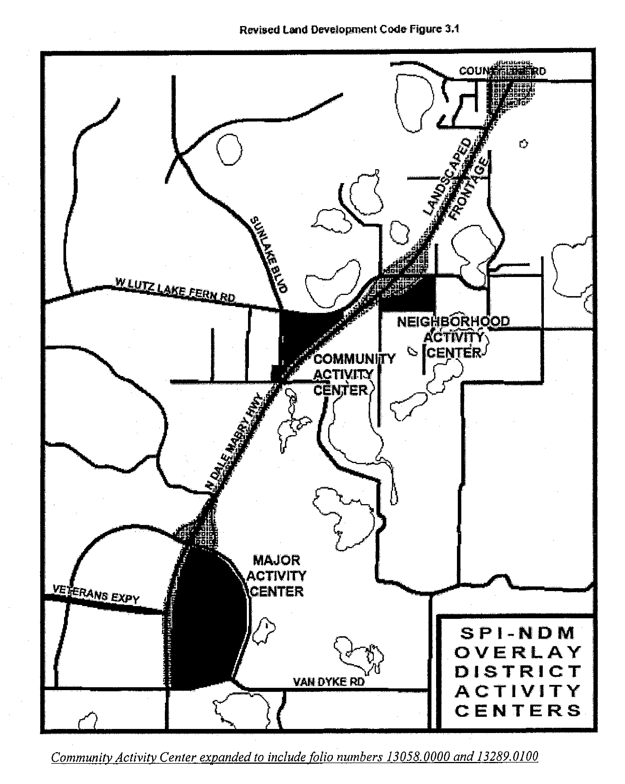
SPI-NDM Overlay District Activity Centers
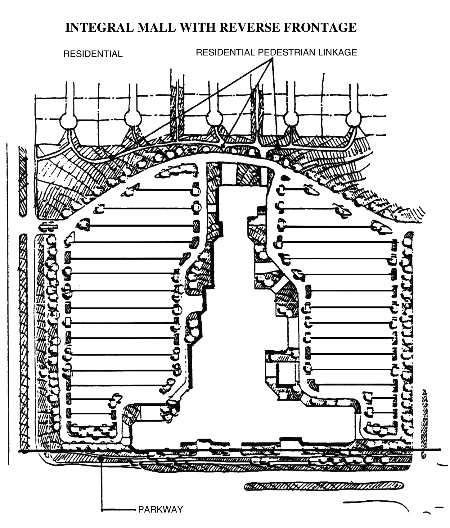
Figure 3.2, Integral Mall with Reverse Frontage
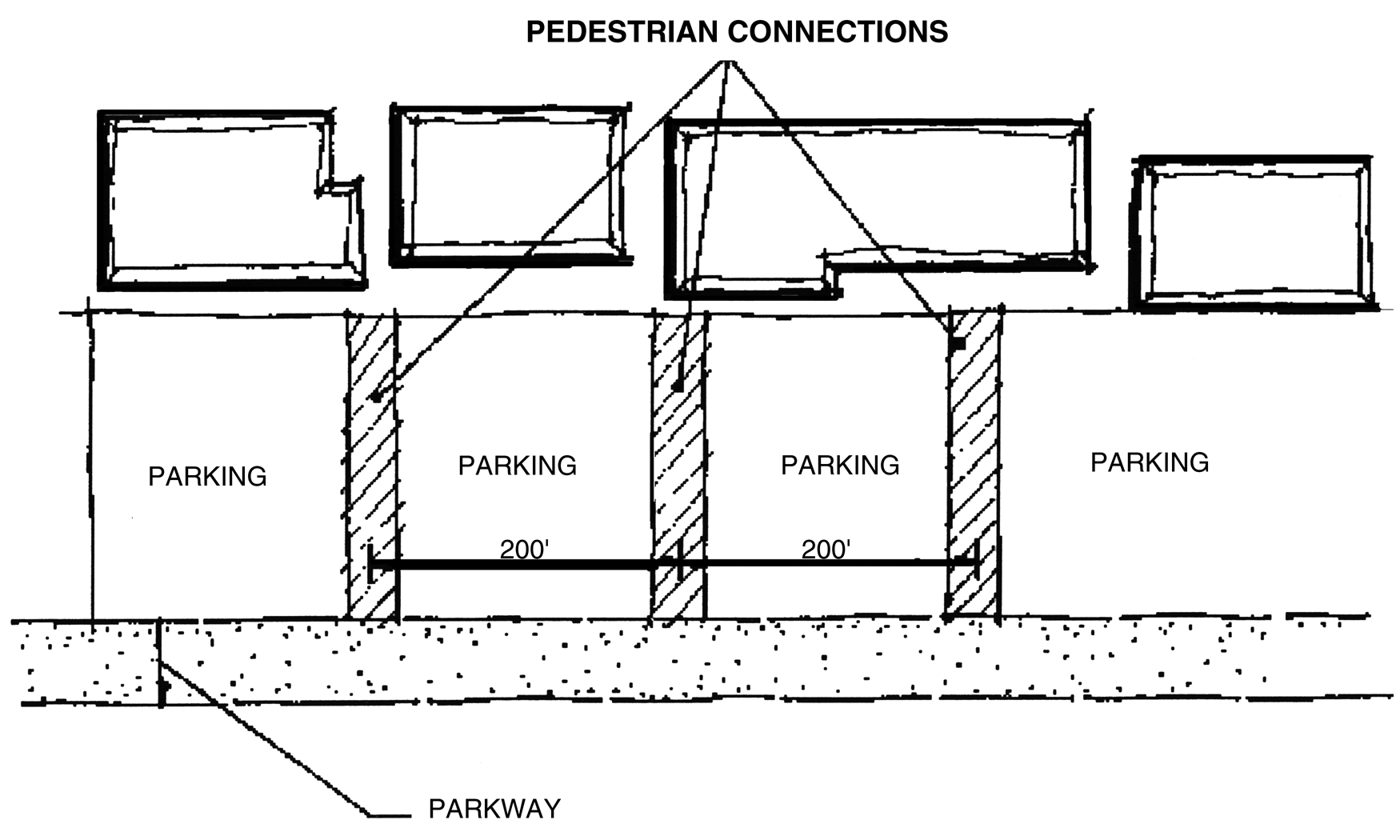
Figure 3.3, Pedestrian Connections
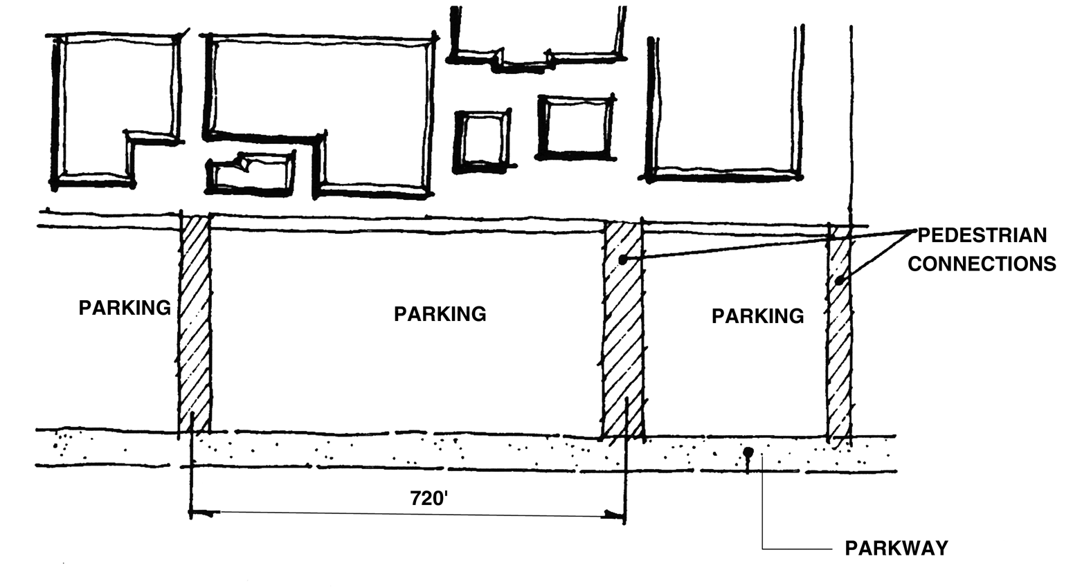
Figure 3.4, Pedestrian Connections
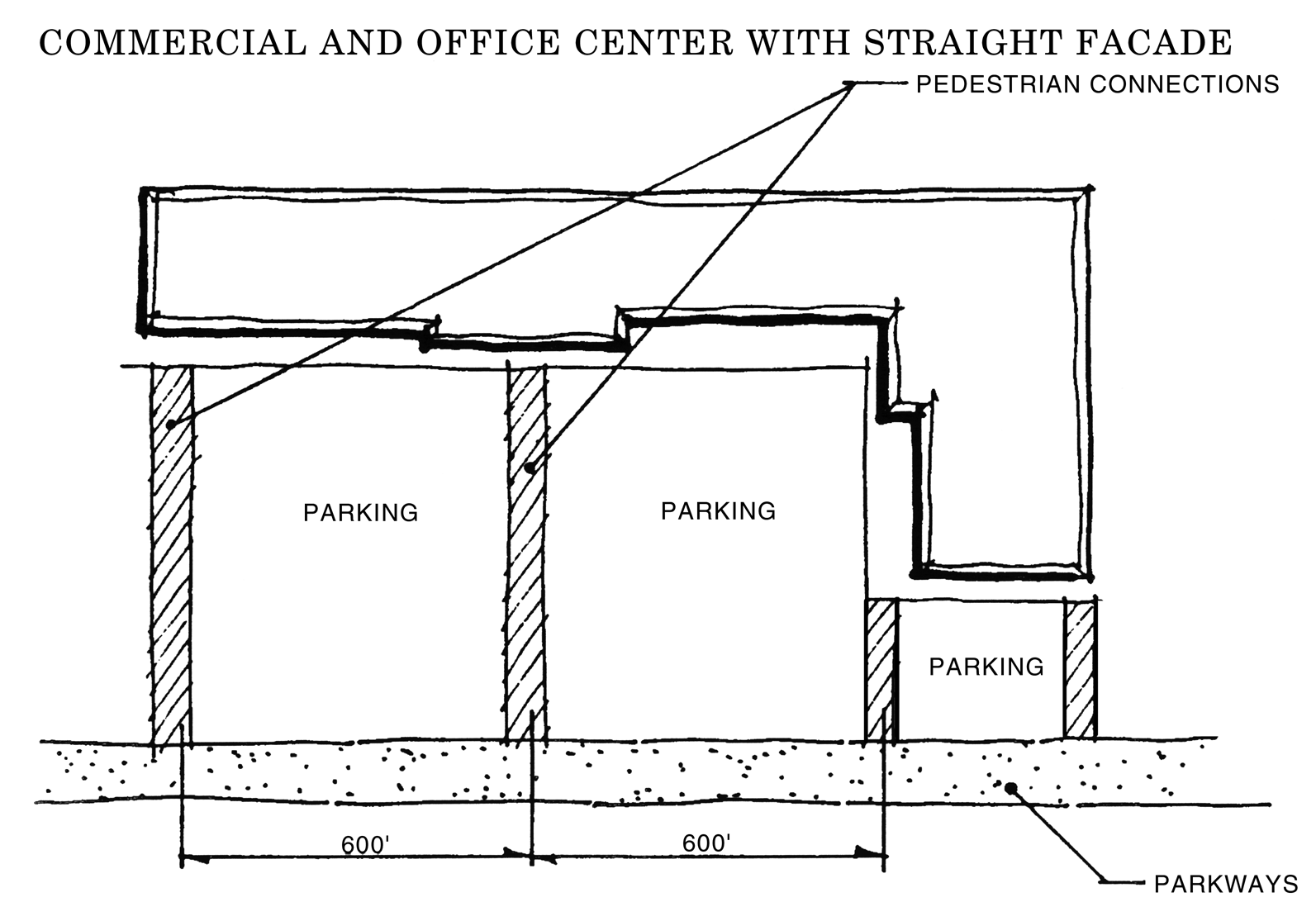
Figure 3.5, Commercial and Office Center with Straight Façade
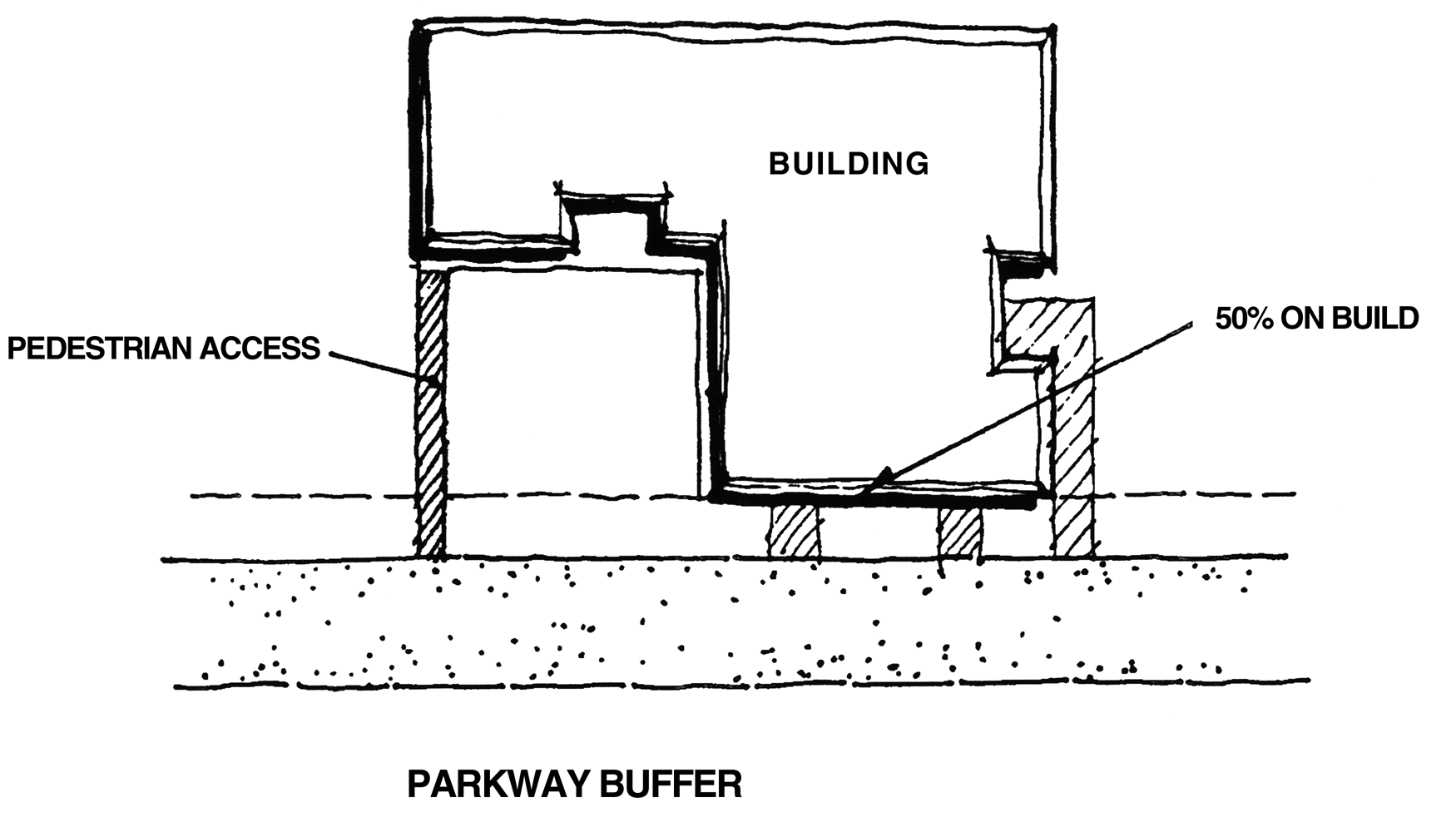
Figure 3.6, Commercial and Office Center with Irregular Façade
F.
Parkway Buffer Area
The parkway buffer is a linear buffer area paralleling and fronting the highway system which is required of all developments fronting onto the corridor transportation network, including North Dale Mabry Highway, frontage roads, or interchange ramps. The parkway buffer shall consist of the following:
1.
Be a minimum of 40 feet in width. Landscaping retention/detention areas, recreation, and bike/pedestrian ways may be included with the parkway buffer.
2.
The retention of existing trees and understory or ground cover beneath the trees within the buffer shall be required, except where its removal for the pedestrian trail is required and where it is essential to cross the buffer with utility lines. Detention is permitted only subject to the standards in 3 below.
3.
Detention or retention areas maybe located in the buffer only where it is located on the inner 25 feet, (the land furthest from Dale Mabry Highway) provided the detention does not cover more than 25 percent of the buffer, and where it shall be located so as to minimize the cutting of any existing trees. There shall be a one to one replacement requirement for any trees cut which shall abe planted on the fringes of the detention or retention facility, or in the case of cypress at appropriate depths within the basin.
4.
A six-foot wide paved bike/pedestrian way shall be provided along the frontage of all development within the parkway buffer, except where a larger pedestrian is otherwise specifically required herein. The alignment of the bike/pedestrian way shall be flexible to accommodate individual site designs. Bike/pedestrian ways shall be required to link adjoining properties as well as the internal circulation system of the project proposed.
5.
Landscaping shall be required within the parkway buffer. All parking areas and other vehicular use areas shall be screened from view with a landscaped hedge a minimum 24 inches in height.
G.
Master Landscaping Plan
There shall be two street tree planning schemes as described below:
1.
Activity Center Planting shall be installed in all activity centers where natural forest conditions are not retained. The length of an activity center's parkway buffer shall determine the amount of landscaping required. For every 40 linear feet of parkway buffer where forests are not being retained, one tree a minimum caliper of two and one-half inches and ten feet in height shall be provided. In addition to the tree plantings, shrubbery or ground cover a minimum of 24 inches in height at time of planting shall be required. For every 40 linear feet of parkway buffer there shall be a minimum of five shrub plantings. See Figure 3.2.
2.
Parkway Street Tree Planting shall be required in all parkways outside the activity centers were natural forest vegetation is not retained. The length of the parkway buffer shall determine the number of tree plantings. For every 40 linear feet of parkway buffer where forest are not being retained, two trees a minimum caliper of two and one-half inches and ten feet in height shall be provided. For example, a parkway buffer of 120 feet in length shall provide a minimum of six trees. See Figure 3.3.
H.
Non-motorized Circulation System
All developments within the NDMC Overlay District shall provide a non-motorized circulation system that connects with adjoining developments as well as other uses internal to a proposed development. The non-motorized circulation system shall be comprised of the following two major components:
1.
A Pedestrian Circulation System shall be provided internal to all planned developments, linking various uses. The pedestrian circulation system shall connect to the external parkway system.
2.
A Bikeway Circulation System shall be provided internal to all planned developments linking various uses and shall be connected to the external parkway system.
(Ord. No. 08-29, § 2, eff. 2-1-09)